IMAGES TAKEN NEAR TO
Blisland, BODMIN, PL30 4LE
Introduction
This page details the photographs taken nearby to PL30 4LE by members of the Geograph project.
The Geograph project started in 2005 with the aim of publishing, organising and preserving representative images for every square kilometre of Great Britain, Ireland and the Isle of Man.

There are currently over 7.5m images from over14,400 individuals and you can help contribute to the project by visiting https://www.geograph.org.uk
Image Map (Loading...)


Getting Data...Please wait
Leaflet Map data © OpenStreetMap
Images are licensed for reuse under creativecommons.org/licenses/by-sa/2.0
Notes
- Clicking on the map will re-center to the selected point.
- The higher the marker number, the further away the image location is from the centre of the postcode.
Image Listing (4 Images Found)
Images are licensed for reuse under creativecommons.org/licenses/by-sa/2.0
Image
Details
Distance
1
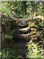
Stone Stile SX1275
Between fields beside the De Lank River between Carbilly and Bradford.
3 stone steps topped with another stone on it edge.
Public footpath 503/6/1 bronze from Bradford to Carbilly.
Two years ago, when a survey of all the footpaths in the parish was carried out for the PC, this stile was completely impassable with branches, wire, and other obstructions across both sides. There is still a fallen tree across part of it, and also barbed wire and wire fencing, but someone has gone to a lot of trouble to clear/remove/cut many of the obstructions, bramble growth, etc, and, with care, it is now passable.
There used to be a small quarry at Carbilly, and this path was originally a short cut to it.
Image: © Anne Green
Taken: 8 Jun 2021
0.14 miles
2
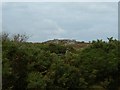
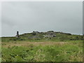
Cheese grater
The Tor has a collection of stones labelled as "Cheesewring". Not _the_ Cheesewring, of course. But here it is hiding behind a fence.
Image: © Gareth
Taken: 12 Sep 2007
0.18 miles