IMAGES TAKEN NEAR TO
Blisland, BODMIN, PL30 4JQ
Introduction
This page details the photographs taken nearby to PL30 4JQ by members of the Geograph project.
The Geograph project started in 2005 with the aim of publishing, organising and preserving representative images for every square kilometre of Great Britain, Ireland and the Isle of Man.

There are currently over 7.5m images from over14,400 individuals and you can help contribute to the project by visiting https://www.geograph.org.uk
Image Map (Loading...)


Getting Data...Please wait
Leaflet Map data © OpenStreetMap
Images are licensed for reuse under creativecommons.org/licenses/by-sa/2.0
Notes
- Clicking on the map will re-center to the selected point.
- The higher the marker number, the further away the image location is from the centre of the postcode.
Image Listing (5 Images Found)
Images are licensed for reuse under creativecommons.org/licenses/by-sa/2.0
Image
Details
Distance
1
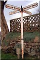
Old Direction Sign - Signpost by Pendrift Council Houses, Blisland parish
Acorn finial - Harris Wadebridge by the UC road, in parish of Blisland (North Cornwall District), Pendrift, North of Blisland, against stone bank.
Cornwall and Scilly HER.
HER Number: MCO55519 https://www.heritagegateway.org.uk/Gateway/Results_Single.aspx?uid=MCO55519&resourceID=1020
Surveyed
Milestone Society National ID: CW_SX1073B
Image: © Milestone Society
Taken: Unknown
0.17 miles
2
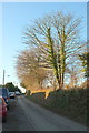
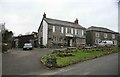
Tregenna Road, Blisland
Houses on the left side of this lane leading away northwestwards from the village.
Image: © Derek Harper
Taken: 25 Jan 2017
0.19 miles
3
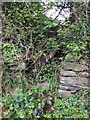
Stone Stile SX1073e
On the lane leading from the village hall towards Pendrift and the moor, on the northern side of Blisland village.
The stile is so grown in that it’s impossible to describe accurately, but, at a guess, it’s 3 or 4 steps up to a granite post at the top.
Not a public footpath. The stile previously gave access to fields belonging to Tumrose Farm and would have been a short cut between the farm house and the village, but there is no designated right of way across the fields.
The footpath is marked and labelled ‘footpath’ on the 1907 Ordnance Survey 25” map.
Image: © Anne Green
Taken: 12 May 2021
0.21 miles
4
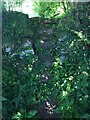
Stone Stile SX0974c
Between two wooden stiles and beside a stream that divides the fields on the Pendrift side of the stream from the fields on the Tregenna side of the stream.
North Side: A high stile that consists of a bank up from the stream then six stone steps of varying widths and distances between the steps and a top pillar stone on its side. South Side: Four steps up to the shared top pillar stone
Public footpath 503/2/1 silver from Pendrift to Tregenna.
Image: © Anne Green
Taken: 1 Jun 2021
0.25 miles
5
Blisland Inn
Not a day for sitting outside enjoying a cider or too. In fact you want the log fire roaring up the chimney as its cold and raw.
Image: © roger geach
Taken: 14 Dec 2009
0.25 miles