IMAGES TAKEN NEAR TO
Blisland, BODMIN, PL30 4JN
Introduction
This page details the photographs taken nearby to PL30 4JN by members of the Geograph project.
The Geograph project started in 2005 with the aim of publishing, organising and preserving representative images for every square kilometre of Great Britain, Ireland and the Isle of Man.

There are currently over 7.5m images from over14,400 individuals and you can help contribute to the project by visiting https://www.geograph.org.uk
Image Map (Loading...)


Getting Data...Please wait
Leaflet Map data © OpenStreetMap
Images are licensed for reuse under creativecommons.org/licenses/by-sa/2.0
Notes
- Clicking on the map will re-center to the selected point.
- The higher the marker number, the further away the image location is from the centre of the postcode.
Image Listing (6 Images Found)
Images are licensed for reuse under creativecommons.org/licenses/by-sa/2.0
Image
Details
Distance
1
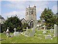
Blisland, Church of St. Protus and St. Hyacinth
This church was one of the first to be discovered in his childhood days by Sir John Betjeman whilst out riding his bicycle. Blisland Church is unusual in that it is on the edge of a village green, the only village in Cornwall to boast one.
Image: © Neil Kennedy
Taken: 15 Sep 2002
0.12 miles
2
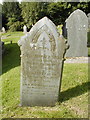
Blisland Church
A sad but fascinating photograph that can be seen in graveyards all over the world.
Image: © Neil Kennedy
Taken: 15 Sep 2002
0.12 miles
3
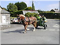
Blisland, Horse and Riders.
I don't know if this is a popular pastime on A Sunday morning in Blisland, but there were a lot about the day that I was there.
Image: © Neil Kennedy
Taken: 15 Sep 2002
0.12 miles
4
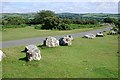
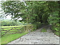
Downland Road
The roadside just south of the high point called The Beacon.
Image: © Tony Atkin
Taken: 23 Jul 2010
0.16 miles
5
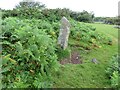
Estate Boundary Marker near The Beacon in Blisland parish
Estate Boundary Marker on a small triangle of moorland formed by the lane from Penquite Marsh to Blisland and the lane to Carwen at the southern end of the section of moor known as The Beacon. Blisland parish.
The 1842 Tithe map shows a group of 3 stones marking a small section of the southern part of the sea of moorland called The Beacon. This stone is the only one that remains. Found lying by the roadside, it was re-erected in 2005 as part of the Blisland Boundary Stone Project. Records show that Sir William Molesworth was in 1842 the Lord of the Manor of Blisland and owned a large part of the part of The Beacon. His mark, MX, is carved on the northeast face and the southwest face bears the mark H for Hayward. Its style and appearance would indicate that it was carved at a later date.
Milestone Society National ID: CW_BLIS44em
Image: © P G Moore
Taken: Unknown
0.18 miles