IMAGES TAKEN NEAR TO
Blisland, BODMIN, PL30 4JF
Introduction
This page details the photographs taken nearby to PL30 4JF by members of the Geograph project.
The Geograph project started in 2005 with the aim of publishing, organising and preserving representative images for every square kilometre of Great Britain, Ireland and the Isle of Man.

There are currently over 7.5m images from over14,400 individuals and you can help contribute to the project by visiting https://www.geograph.org.uk
Image Map
Images are licensed for reuse under creativecommons.org/licenses/by-sa/2.0
Notes
- Clicking on the map will re-center to the selected point.
- The higher the marker number, the further away the image location is from the centre of the postcode.
Image Listing (89 Images Found)
Images are licensed for reuse under creativecommons.org/licenses/by-sa/2.0
Image
Details
Distance
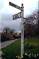
1
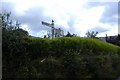
Old Direction Sign - Signpost at Blisland
Raised finial; by the UC road, in parish of Blisland (North Cornwall District), Blisland.
To be surveyed
Milestone Society National ID: CW_SX1073C.
Image: © Milestone Society
Taken: Unknown
0.02 miles
2
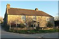
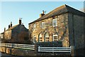
Manor House, Blisland
Listed as "Mansion House", with a very detailed description at https://www.historicengland.org.uk/listing/the-list/list-entry/1311659 . " Circa late C16 or earlier ... The house was converted into a series of cottages in circa C18 or C19 and converted back into 1 house and restored in the late C20."
NCN3 uses the lane on the left.
Image: © Derek Harper
Taken: 25 Jan 2017
0.03 miles
3
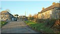
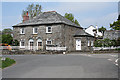
Houses at Blisland
Around the northeast corner of the village green. On the left is Pope's Cottage https://www.historicengland.org.uk/listing/the-list/list-entry/1158111 ; on the right is the Manor House, grade II* listed and listed as "Mansion House", with a very detailed description at https://www.historicengland.org.uk/listing/the-list/list-entry/1311659 . In the centre, easily overlooked, is the listed Pigshouse https://www.historicengland.org.uk/listing/the-list/list-entry/1328267 .
Image: © Derek Harper
Taken: 25 Jan 2017
0.03 miles
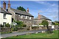
5
Listed buildings, Blisland
In the foreground is Pope's Cottage https://www.historicengland.org.uk/listing/the-list/list-entry/1158111 ; beyond is Homeleigh https://www.historicengland.org.uk/listing/the-list/list-entry/1142370 . The houses face the green across a road used by NCN3.
Image: © Derek Harper
Taken: 25 Jan 2017
0.04 miles
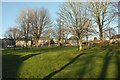
6
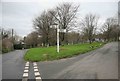
Blisland Village green and signpost
The view on arrival at Blisland from the Cardinham road. Blisland has a large village green which is unusual for Cornish villages.
Image: © roger geach
Taken: 14 Dec 2009
0.04 miles
7
Blisland: Pope's Cottage
By the village green in Blisland village. The cottage dates from 1833 and is faced in granite with a slate roof - both materials available from quarries nearby
Image: © Martin Bodman
Taken: 4 May 2011
0.05 miles
8
The church from the village green, Blisland
Image: © Humphrey Bolton
Taken: 6 Mar 2001
0.06 miles
9
Old Direction Sign - Signpost by Blisland village green
Pyramid spear finial - 3 arms; Cornwall CC iron spear by the UC road, in parish of Blisland (North Cornwall District), Blisland village green, South side near church.
Surveyed
Milestone Society National ID: CW_SX1073A
Image: © Milestone Society
Taken: Unknown
0.06 miles
10
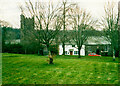
Green, Blisland
Looking across the green from the south side to listed houses along the north side.
Image: © Derek Harper
Taken: 25 Jan 2017
0.06 miles