IMAGES TAKEN NEAR TO
Warleggan, Mount, BODMIN, PL30 4HF
Introduction
This page details the photographs taken nearby to PL30 4HF by members of the Geograph project.
The Geograph project started in 2005 with the aim of publishing, organising and preserving representative images for every square kilometre of Great Britain, Ireland and the Isle of Man.

There are currently over 7.5m images from over14,400 individuals and you can help contribute to the project by visiting https://www.geograph.org.uk
Image Map
Images are licensed for reuse under creativecommons.org/licenses/by-sa/2.0
Notes
- Clicking on the map will re-center to the selected point.
- The higher the marker number, the further away the image location is from the centre of the postcode.
Image Listing (7 Images Found)
Images are licensed for reuse under creativecommons.org/licenses/by-sa/2.0
Image
Details
Distance
1
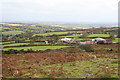
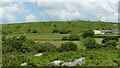
Moorland on the south slope of Carburrow Tor
Looking towards Tor House, currently undergoing extensive refurbishment.
Image: © Rod Allday
Taken: 18 Oct 2009
0.18 miles
2
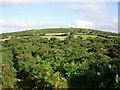
Warleggan Down
Looking towards Tor House
Image: © Hugh Venables
Taken: 12 Aug 2006
0.20 miles
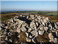
4
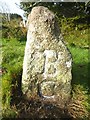
Old Boundary Marker
Estate Boundary Marker on Warleggan Down. WARLEGGAN parish. Inscribed B / C, perhaps for William Bickford Coham.
Milestone Society National ID: CW_WARL17em
Image: © R Hanns
Taken: 10 Oct 2019
0.23 miles
7
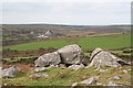
Boulders on Carburrow Tor
Looking towards the old Glynn Valley china clay works in square SX1471.
Image: © Rod Allday
Taken: 18 Oct 2009
0.25 miles