IMAGES TAKEN NEAR TO
Mount, BODMIN, PL30 4EY
Introduction
This page details the photographs taken nearby to PL30 4EY by members of the Geograph project.
The Geograph project started in 2005 with the aim of publishing, organising and preserving representative images for every square kilometre of Great Britain, Ireland and the Isle of Man.

There are currently over 7.5m images from over14,400 individuals and you can help contribute to the project by visiting https://www.geograph.org.uk
Image Map (Loading...)


Getting Data...Please wait
Leaflet Map data © OpenStreetMap
Images are licensed for reuse under creativecommons.org/licenses/by-sa/2.0
Notes
- Clicking on the map will re-center to the selected point.
- The higher the marker number, the further away the image location is from the centre of the postcode.
Image Listing (8 Images Found)
Images are licensed for reuse under creativecommons.org/licenses/by-sa/2.0
Image
Details
Distance

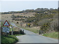
3
Signpost and cattle grid on Treslea Downs
A granite base supports the upright and arms of the signpost
Image: © David Smith
Taken: 20 Mar 2013
0.08 miles
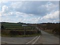
5
The edge of Treslea Downs
On the right is a sign for Mount Pleasant Farm, on the edge of the hamlet of Mount
Image: © David Smith
Taken: 20 Mar 2013
0.14 miles
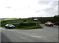
6
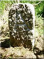
Old Boundary Marker
Estate Boundary Marker on the southern slope of Treslea Downs. CARDINHAM parish. Inscribed A on its centre face.
Milestone Society National ID: CW_CARD02em
Image: © R Hanns
Taken: 21 Jun 2019
0.15 miles
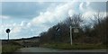
7
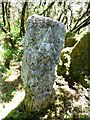
Old Boundary Marker
Estate Boundary Marker on the southern slope of Treslea Downs. CARDINHAM parish. Inscribed A on its centre face.
Milestone Society National ID: CW_CARD03em
Image: © R Hanns
Taken: 21 Jun 2019
0.18 miles
8
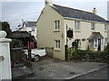
Sunnyside Forge
A business in the hamlet of Mount.
Image: © Jonathan Billinger
Taken: 3 Oct 2007
0.20 miles