IMAGES TAKEN NEAR TO
Treswithick, BODMIN, PL30 4BH
Introduction
This page details the photographs taken nearby to Treswithick, PL30 4BH by members of the Geograph project.
The Geograph project started in 2005 with the aim of publishing, organising and preserving representative images for every square kilometre of Great Britain, Ireland and the Isle of Man.

There are currently over 7.5m images from over14,400 individuals and you can help contribute to the project by visiting https://www.geograph.org.uk
Image Map
Images are licensed for reuse under creativecommons.org/licenses/by-sa/2.0
Notes
- Clicking on the map will re-center to the selected point.
- The higher the marker number, the further away the image location is from the centre of the postcode.
Image Listing (4 Images Found)
Images are licensed for reuse under creativecommons.org/licenses/by-sa/2.0
Image
Details
Distance
1
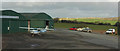
Bodmin Airfield
A Cessna 152 outside the hangar at the airfield near Cardinham.
Image: © Derek Harper
Taken: 2 Feb 2018
0.16 miles
2

Path to the control tower, Bodmin Airfield
And, as the sign indicates, to the clubhouse, bar and restaurant of the Cornwall Flying Club. On the right is the main hangar.
Image: © Derek Harper
Taken: 2 Feb 2018
0.20 miles
3
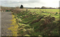
Car park, Bodmin Airfield
Looking left from where Image] was taken, with the airfield on the right and behind the camera.
Image: © Derek Harper
Taken: 2 Feb 2018
0.20 miles
4
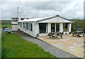
The Clubhouse, Cardinham airfield
Headquarters of the Cornwall Flying Club.
Image: © Humphrey Bolton
Taken: 4 May 2009
0.24 miles