IMAGES TAKEN NEAR TO
St. Tudy, BODMIN, PL30 3PS
Introduction
This page details the photographs taken nearby to PL30 3PS by members of the Geograph project.
The Geograph project started in 2005 with the aim of publishing, organising and preserving representative images for every square kilometre of Great Britain, Ireland and the Isle of Man.

There are currently over 7.5m images from over14,400 individuals and you can help contribute to the project by visiting https://www.geograph.org.uk
Image Map
Images are licensed for reuse under creativecommons.org/licenses/by-sa/2.0
Notes
- Clicking on the map will re-center to the selected point.
- The higher the marker number, the further away the image location is from the centre of the postcode.
Image Listing (5 Images Found)
Images are licensed for reuse under creativecommons.org/licenses/by-sa/2.0
Image
Details
Distance
1
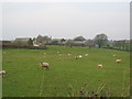
Tinten Manor Farm
A view looking to the northwest from the B3266, across farmland towards Tinten Manor Farm.
Image: © Phil Williams
Taken: 25 Mar 2007
0.03 miles
2
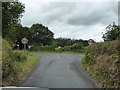
Junction of a minor road with the B3266 near Tinten Manor
Image: © Rod Allday
Taken: 1 Aug 2017
0.10 miles
3
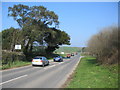
B3266 at Tinten Manor Farm
A view looking to the northeast along the B3266 showing the entrance to Tinten Manor Farm and the junction for Wenford Bridge.
Image: © Phil Williams
Taken: 24 Mar 2007
0.12 miles
4
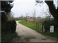
Entrance to Tinten Manor Farm
A view looking to the northwest from the B3266 at the entrance to Tinten Manor Farm.
Image: © Phil Williams
Taken: 25 Mar 2007
0.12 miles
5
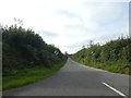
Straight road to St Tudy
The straight road, which is matched by long straight boundaries to nearby fields, suggests that this is an enclosure road
Image: © David Smith
Taken: 7 Sep 2020
0.17 miles