IMAGES TAKEN NEAR TO
Normans Way, BODMIN, PL30 3NU
Introduction
This page details the photographs taken nearby to Normans Way, PL30 3NU by members of the Geograph project.
The Geograph project started in 2005 with the aim of publishing, organising and preserving representative images for every square kilometre of Great Britain, Ireland and the Isle of Man.

There are currently over 7.5m images from over14,400 individuals and you can help contribute to the project by visiting https://www.geograph.org.uk
Image Map
Images are licensed for reuse under creativecommons.org/licenses/by-sa/2.0
Notes
- Clicking on the map will re-center to the selected point.
- The higher the marker number, the further away the image location is from the centre of the postcode.
Image Listing (23 Images Found)
Images are licensed for reuse under creativecommons.org/licenses/by-sa/2.0
Image
Details
Distance
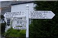
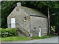
1
St Tudy Cottages and attractive signpost
Cornish cottages by this road junction with an attractive well painted signpost.
Image: © roger geach
Taken: 14 Dec 2009
0.07 miles
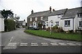
2
Old Direction Sign - Signpost by Chapel Road, St Tudy
Ogee finial - 5 arms; Granite base with post and fingers by the UC road, in parish of St Tudy (North Cornwall District), St Tudy village, grassy area. Junction of Chapel Road and Wadebridge Road.
To be surveyed
Milestone Society National ID: CW_SX0676.
Image: © Milestone Society
Taken: Unknown
0.10 miles
4
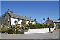
St Tudy cottage
One of many charming cottages in this lovely village. Note the "Cornish ensign" (St Piran's cross with a Union flag in the corner) proudly flying...
(see: http://en.wikipedia.org/wiki/Saint_Piran's_Flag )
Image: © Bill Harrison
Taken: 24 Jul 2012
0.12 miles
5
The Clink
https://historicengland.org.uk/listing/the-list/list-entry/1162270?section=official-list-entry
Image: © Sandy Gerrard
Taken: 19 Jun 2024
0.12 miles
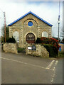
6
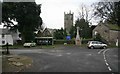
St Tudy Church
St Tudy church found in the middle of the village with the war memorial alongside.On the left is the village pump and some mill stones.
Image: © roger geach
Taken: 14 Dec 2009
0.13 miles
7
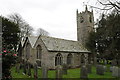
St Tudy church
St Tudy church dates from the 15th century and underwent restoration work in the 19th century.
Image: © Philip Halling
Taken: 21 Feb 2012
0.14 miles
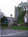
9
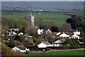
St Tudy Village
Gorgeous Cornish village.
Image: © David Balmford
Taken: 4 May 2008
0.14 miles
10
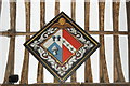
Hatchment, St Tudius Church, St Tudy
A hatchment is a rendering of a dead person's achievement (coat of arms) on a lozenge-shaped background. It would have been placed at their residence for a few weeks after their death and then transferred to the ceiling of the church (as here). The husband's arms to the left are the Sarrel (or Sarel) family (Per chevron argent and azure three garbs counterchanged) of St Tudy and the wife's to the right seem to correspond to the Harvey (or Hervey) family (Gules on a bend argent three trefoils slipped vert). The celestial cherub at the top and all-black background colour indicate that the husband predeceased his wife. See: Burke's General Armory, 1884 edition, page xxi (available on archive.org) for more.
Image: © Bill Harrison
Taken: 24 Jul 2012
0.14 miles