IMAGES TAKEN NEAR TO
Trelill, BODMIN, PL30 3HZ
Introduction
This page details the photographs taken nearby to PL30 3HZ by members of the Geograph project.
The Geograph project started in 2005 with the aim of publishing, organising and preserving representative images for every square kilometre of Great Britain, Ireland and the Isle of Man.

There are currently over 7.5m images from over14,400 individuals and you can help contribute to the project by visiting https://www.geograph.org.uk
Image Map (Loading...)


Getting Data...Please wait
Leaflet Map data © OpenStreetMap
Images are licensed for reuse under creativecommons.org/licenses/by-sa/2.0
Notes
- Clicking on the map will re-center to the selected point.
- The higher the marker number, the further away the image location is from the centre of the postcode.
Image Listing (5 Images Found)
Images are licensed for reuse under creativecommons.org/licenses/by-sa/2.0
Image
Details
Distance
1
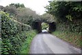
North Cornwall Railway old railway bridge
This view shows the old railway bridge crossing a minor road. just under the bridge a now private lane to the left took you to what was once the station named as Port Isaac Road.
Image: © roger geach
Taken: 23 Sep 2010
0.03 miles
2
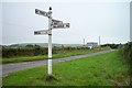
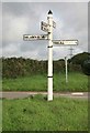
Old Direction Sign - Signpost west of Trevorrian, St Kew parish
Pyramid finial - 4 arms; Cornwall by the UC road, in parish of St Kew (North Cornwall District), by crossroads west of Trevorrian, on verge.
Surveyed
Milestone Society National ID: CW_SX0479A
Image: © Milestone Society
Taken: Unknown
0.12 miles
5
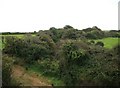
North Cornwall Railway trackbed on the curve
The course of the old North Cornwall railway is clearly seen here curving away from the road overbridge.
Image: © roger geach
Taken: 23 Sep 2010
0.19 miles