IMAGES TAKEN NEAR TO
Pendoggett, St. Kew, BODMIN, PL30 3HQ
Introduction
This page details the photographs taken nearby to PL30 3HQ by members of the Geograph project.
The Geograph project started in 2005 with the aim of publishing, organising and preserving representative images for every square kilometre of Great Britain, Ireland and the Isle of Man.

There are currently over 7.5m images from over14,400 individuals and you can help contribute to the project by visiting https://www.geograph.org.uk
Image Map (Loading...)


Getting Data...Please wait
Leaflet Map data © OpenStreetMap
Images are licensed for reuse under creativecommons.org/licenses/by-sa/2.0
Notes
- Clicking on the map will re-center to the selected point.
- The higher the marker number, the further away the image location is from the centre of the postcode.
Image Listing (8 Images Found)
Images are licensed for reuse under creativecommons.org/licenses/by-sa/2.0
Image
Details
Distance
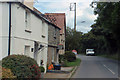
2
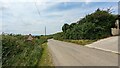
Pendoggett
The road from St Endellion and Port Isaac enters Pendoggett from the left
Image: © William Bartlett
Taken: 29 May 2007
0.08 miles
3
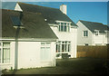
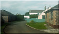
Modern houses in Pendoggett
By the B3314.
Image: © Derek Harper
Taken: 5 Feb 2018
0.09 miles
4
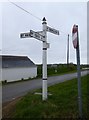
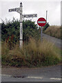
Old Direction Sign - Signpost by Pendoggett, St Kew parish
Pyramid finial - Lowest arm broken at sleeve; Cornwall by the UC road, in parish of St Kew (North Cornwall District), South of Pendogget, opposite cottages, on verge at crossroads.
Cornwall & Scilly HER.
HER Number: MCO56956 https://www.heritagegateway.org.uk/Gateway/Results_Single.aspx?uid=MCO56956&resourceID=1020
Surveyed
Milestone Society National ID: CW_SX0279
Image: © Alan Rosevear
Taken: 20 Mar 2014
0.12 miles
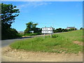
7
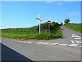
Country Lane and Weathered Sign near Pendoggett
Hard to see how useful this sign is in this condition.
Image: © Sandy Gerrard
Taken: 19 Jun 2024
0.16 miles
8
Treore Close, Pendoggett
A cul-de-sac containing the most north-easterly houses in the village on the north side of the B3314.
Image: © Derek Harper
Taken: 5 Feb 2018
0.17 miles