IMAGES TAKEN NEAR TO
St. Kew Highway, BODMIN, PL30 3EF
Introduction
This page details the photographs taken nearby to PL30 3EF by members of the Geograph project.
The Geograph project started in 2005 with the aim of publishing, organising and preserving representative images for every square kilometre of Great Britain, Ireland and the Isle of Man.

There are currently over 7.5m images from over14,400 individuals and you can help contribute to the project by visiting https://www.geograph.org.uk
Image Map
Images are licensed for reuse under creativecommons.org/licenses/by-sa/2.0
Notes
- Clicking on the map will re-center to the selected point.
- The higher the marker number, the further away the image location is from the centre of the postcode.
Image Listing (11 Images Found)
Images are licensed for reuse under creativecommons.org/licenses/by-sa/2.0
Image
Details
Distance
1
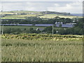
Solar PV Farm at Benbole Farm, St Kew Highway
This site developed in the last couple of months and due to go 'online' with the National Grid by end of July 2011.
Viewed from lane between Killibury Castle and Rocksea Farm and with 'Leeches' farm between.
Image: © Tamsyn Cleave [nee Oram]
Taken: 29 Jun 2011
0.09 miles
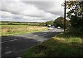
2
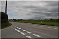
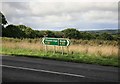
North Cornwall : The A39
A junction of the A39 between Camelford and Wadebridge.
Image: © Lewis Clarke
Taken: 1 Jul 2011
0.09 miles
3
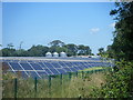
More Cornish Power
There are already 12 solar farms in Cornwall and another 24 have permission to be built on farmland. The largest will have a capacity of around 5MW, enough to supply around 1,000 homes.
Read more: http://www.dailymail.co.uk/news/article-2175668/Britain-s-biggest-UK-solar-farm-unveiled-Huge-224-acre-site-comprising-135-000-panels-built-Cornish-farmland.html#ixzz21XLnqgb9
Image: © William Bartlett
Taken: 20 Jul 2012
0.09 miles
4
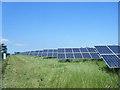
Cornish Power
Silicon Vineyards, developed this solar park at Benbole Farm in 2011. Presumably trying to beat the cut in government subsidies http://www.guardian.co.uk/environment/2011/jul/07/uk-solar-farms
Image: © William Bartlett
Taken: 22 Jul 2012
0.12 miles
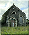
5
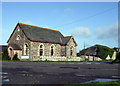
Roadside Chapel
Disused chapel on the west side of the A39 half a mile south of St Kew Highway
Image: © David Balmford
Taken: 24 Apr 2008
0.13 miles
6
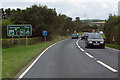
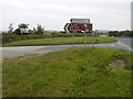
The A39
Approaching services at St Kew's Highway.
Image: © Robert Ashby
Taken: 21 Aug 2014
0.13 miles
7
The Atlantic Highway A39
Looking towards St Kew
Image: © roger geach
Taken: 23 Sep 2010
0.15 miles
10
The Road to St. Endellion
Exploring the favourite churches of Sir John Betjeman, shows you the turn off from the A39 taking you down Hendra Lane towards your destination.
Image: © Neil Kennedy
Taken: 15 Sep 2002
0.20 miles