IMAGES TAKEN NEAR TO
St. Kew, BODMIN, PL30 3DY
Introduction
This page details the photographs taken nearby to PL30 3DY by members of the Geograph project.
The Geograph project started in 2005 with the aim of publishing, organising and preserving representative images for every square kilometre of Great Britain, Ireland and the Isle of Man.

There are currently over 7.5m images from over14,400 individuals and you can help contribute to the project by visiting https://www.geograph.org.uk
Image Map (Loading...)


Getting Data...Please wait
Leaflet Map data © OpenStreetMap
Images are licensed for reuse under creativecommons.org/licenses/by-sa/2.0
Notes
- Clicking on the map will re-center to the selected point.
- The higher the marker number, the further away the image location is from the centre of the postcode.
Image Listing (5 Images Found)
Images are licensed for reuse under creativecommons.org/licenses/by-sa/2.0
Image
Details
Distance
3
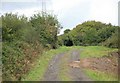
North Cornwall Railway trackbed
This was the embankment which carried the former North Cornwall Railway looking towards Port Isaac Road the next station. A newer track leads down from the old embankment to give access to the lane nearby.
Image: © roger geach
Taken: 23 Sep 2010
0.21 miles
4
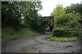
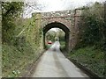
North Cornwall Railway Trequite
A rail overbridge still stands on this minor road nr Trequite.The line shut in 1966.
Image: © roger geach
Taken: 23 Sep 2010
0.23 miles
5
Disused railway bridge
That once carried the North Cornish Railway between St Kew Highway and Trelill. This section of the line was opened in 1893 and closed in 1966.
Image: © John Baker
Taken: 28 Mar 2013
0.24 miles