IMAGES TAKEN NEAR TO
St. Kew Highway, BODMIN, PL30 3DR
Introduction
This page details the photographs taken nearby to PL30 3DR by members of the Geograph project.
The Geograph project started in 2005 with the aim of publishing, organising and preserving representative images for every square kilometre of Great Britain, Ireland and the Isle of Man.

There are currently over 7.5m images from over14,400 individuals and you can help contribute to the project by visiting https://www.geograph.org.uk
Image Map
Images are licensed for reuse under creativecommons.org/licenses/by-sa/2.0
Notes
- Clicking on the map will re-center to the selected point.
- The higher the marker number, the further away the image location is from the centre of the postcode.
Image Listing (3 Images Found)
Images are licensed for reuse under creativecommons.org/licenses/by-sa/2.0
Image
Details
Distance
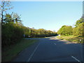
2
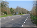
Picnic area off the A39
A view looking to the northeast along the A39 Atlantic Highway towards a large picnic area.
Image: © Phil Williams
Taken: 26 Mar 2007
0.16 miles
3
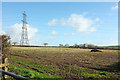
Field near Great Brighter Farm
Looking right from the same spot as Image, with the same pylon.
Image: © Derek Harper
Taken: 1 Feb 2018
0.24 miles