IMAGES TAKEN NEAR TO
Longstone, St. Mabyn, BODMIN, PL30 3DA
Introduction
This page details the photographs taken nearby to PL30 3DA by members of the Geograph project.
The Geograph project started in 2005 with the aim of publishing, organising and preserving representative images for every square kilometre of Great Britain, Ireland and the Isle of Man.

There are currently over 7.5m images from over14,400 individuals and you can help contribute to the project by visiting https://www.geograph.org.uk
Image Map
Images are licensed for reuse under creativecommons.org/licenses/by-sa/2.0
Notes
- Clicking on the map will re-center to the selected point.
- The higher the marker number, the further away the image location is from the centre of the postcode.
Image Listing (11 Images Found)
Images are licensed for reuse under creativecommons.org/licenses/by-sa/2.0
Image
Details
Distance
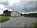
1
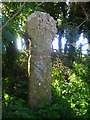
Penwine Cross
Overgrown at a road junction.
Image: © William Bartlett
Taken: 8 Aug 2007
0.09 miles
2
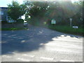
Longstone crossroads
In the small wood are three stones. One is part of a stone broken up for gateposts and re-located here to share the overgrown wooded ground with the Penwine Cross.
Image: © William Bartlett
Taken: 8 Aug 2007
0.09 miles

4
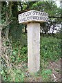
Old Guide Stone by the B3266, Longstone, St Mabyn parish
Carved stone post by the B3266, in parish of St Mabyn (North Cornwall District), Longstone, near Cornish cross and 4ft high standing stone.
Inscription reads:-
: BODMIN / ST.AUSTELL : : ST.MABYN / WADEBRIDGE : : ST.TUDY / CAMELFORD : : BLISLAND / LISKEARD :
Grade II listed.
List Entry Number: 1143006 https://historicengland.org.uk/listing/the-list/list-entry/1143006
Surveyed
Milestone Society National ID: CW_XSTM2
Image: © Milestone Society
Taken: Unknown
0.10 miles
5
Old Guide Stone by the B3266, Longstone, St Mabyn parish
Carved stone by the B3266, in parish of St Mabyn (North Cornwall District), Longstone, near Cornish cross and 4ft high standing stone.
Inscription reads:-
: BODMIN / ST.AUSTELL : : ST.MABYN / WADEBRIDGE : : ST.TUDY / CAMELFORD : : BLISLAND / LISKEARD :
Grade II listed.
List Entry Number: 1143006 https://historicengland.org.uk/listing/the-list/list-entry/1143006
Surveyed
Milestone Society National ID: CW_XSTM2
Image: © Rosy Hanns
Taken: 19 Apr 2019
0.10 miles
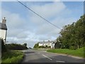
6
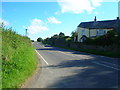
B3266 at Longstone
Looking towards Hendra (just over the brow)
Image: © William Bartlett
Taken: 7 Aug 2007
0.11 miles
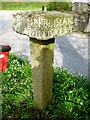
7
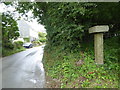
Guidepost at Longstone
Grade II Listed with the following description 'Guide post. Circa aid C19. Granite. Tall square section shaft on which there is a large square cap with a pyramid top. Directions to St Tudy, Camelford, Blisland, Liskeard, Bodmin, St Austell, St Mabyn and Wadebridge marked on the 4 faces of the cap in upper case lettering. The wrought iron shaft on the top of the cap may have been for direction pointers.'
Image: © Rod Allday
Taken: 1 Aug 2017
0.11 miles
10
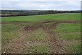
Arable field near Longstone
View south over an arable field to the east of Longstone.
Image: © Philip Halling
Taken: 21 Feb 2012
0.16 miles