IMAGES TAKEN NEAR TO
Trelights, PORT ISAAC, PL29 3AD
Introduction
This page details the photographs taken nearby to PL29 3AD by members of the Geograph project.
The Geograph project started in 2005 with the aim of publishing, organising and preserving representative images for every square kilometre of Great Britain, Ireland and the Isle of Man.

There are currently over 7.5m images from over14,400 individuals and you can help contribute to the project by visiting https://www.geograph.org.uk
Image Map
Images are licensed for reuse under creativecommons.org/licenses/by-sa/2.0
Notes
- Clicking on the map will re-center to the selected point.
- The higher the marker number, the further away the image location is from the centre of the postcode.
Image Listing (4 Images Found)
Images are licensed for reuse under creativecommons.org/licenses/by-sa/2.0
Image
Details
Distance
1
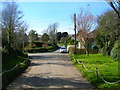
Trelights lane junction
Looking back into the quiet Cornish village of Trelights
Image: © William Bartlett
Taken: 6 Apr 2007
0.05 miles
2
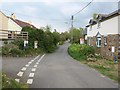
Lane, Trelights
This lane runs through the village and becomes a route with public access to St Endellion.
Image: © Derek Harper
Taken: 27 Apr 2011
0.08 miles
3
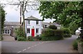
Old post office, Trelights
The former post office is now a holiday cottage. The nearest real post office is at Port Isaac.
Image: © Derek Harper
Taken: 27 Apr 2011
0.09 miles
4
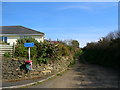
Trelights Bridleway to St Endellion
Up past the cul-de-sacs and new bungalows of Trelights is the start to a short walk up to the church at St Endellion
Image: © William Bartlett
Taken: 6 Apr 2007
0.12 miles