IMAGES TAKEN NEAR TO
Harlyn Bay, PADSTOW, PL28 8SA
Introduction
This page details the photographs taken nearby to PL28 8SA by members of the Geograph project.
The Geograph project started in 2005 with the aim of publishing, organising and preserving representative images for every square kilometre of Great Britain, Ireland and the Isle of Man.

There are currently over 7.5m images from over14,400 individuals and you can help contribute to the project by visiting https://www.geograph.org.uk
Image Map (Loading...)


Getting Data...Please wait
Leaflet Map data © OpenStreetMap
Images are licensed for reuse under creativecommons.org/licenses/by-sa/2.0
Notes
- Clicking on the map will re-center to the selected point.
- The higher the marker number, the further away the image location is from the centre of the postcode.
Image Listing (4 Images Found)
Images are licensed for reuse under creativecommons.org/licenses/by-sa/2.0
Image
Details
Distance
1
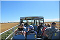
View from the Atlantic Coaster bus shortly after Harlyn Bay
Image: © Roy Hughes
Taken: 9 Jul 2022
0.13 miles
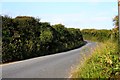
3
Road, Harlyn
The road, carrying NCN 323, runs away from the car park towards Trevone. On the right are public conveniences.
Image: © Derek Harper
Taken: 7 Feb 2019
0.18 miles
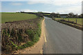
4

Field, Harlyn
Looking left from where Image] was taken, with overlap.
Image: © Derek Harper
Taken: 7 Feb 2019
0.18 miles