IMAGES TAKEN NEAR TO
Newquay Road, PADSTOW, PL28 8RS
Introduction
This page details the photographs taken nearby to Newquay Road, PL28 8RS by members of the Geograph project.
The Geograph project started in 2005 with the aim of publishing, organising and preserving representative images for every square kilometre of Great Britain, Ireland and the Isle of Man.

There are currently over 7.5m images from over14,400 individuals and you can help contribute to the project by visiting https://www.geograph.org.uk
Image Map
Images are licensed for reuse under creativecommons.org/licenses/by-sa/2.0
Notes
- Clicking on the map will re-center to the selected point.
- The higher the marker number, the further away the image location is from the centre of the postcode.
Image Listing (9 Images Found)
Images are licensed for reuse under creativecommons.org/licenses/by-sa/2.0
Image
Details
Distance
6
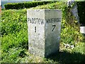
Old Milestone by the B3276, south of Trecerus Farm
Carved stone post by the B3276, in parish of PADSTOW (NORTH CORNWALL District), South of Trecerus Farm, Newquay road by-passing Padstow, on West side of road. Erected by the Local Highways Board in the 19th century.
Inscription reads:-
: PADSTOW / 1 : : WADEBRIDGE / 7 :
Grade II listed.
List Entry Number: 1211505 https://historicengland.org.uk/listing/the-list/list-entry/1211505
Milestone Society National ID: CW_PSWB01.
Image: © Rosy Hanns
Taken: 11 May 2019
0.20 miles
7
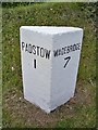
Old Milestone by the B3276, south of Trecerus Farm
Carved stone post by the B3276, in parish of PADSTOW (NORTH CORNWALL District), South of Trecerus Farm, Newquay road by-passing Padstow, on West side of road. Erected by the Local Highways Board in the 19th century.
Inscription reads:-
: PADSTOW / 1 : : WADEBRIDGE / 7 :
Grade II Listed. List Entry Number: 1211505
https://historicengland.org.uk/listing/the-list/list-entry/1211505
Milestone Society National ID: CW_PSWB01.
Image: © Ian Thompson
Taken: 10 Dec 2017
0.20 miles
9
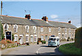
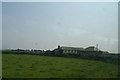
Cottages at Treator
Looking east at a fine row of cottages beside the B3276 at Treator, a mile west of Padstow.
Image: © Andy F
Taken: 25 Aug 2009
0.24 miles