IMAGES TAKEN NEAR TO
Rope Walk, PADSTOW, PL28 8RG
Introduction
This page details the photographs taken nearby to Rope Walk, PL28 8RG by members of the Geograph project.
The Geograph project started in 2005 with the aim of publishing, organising and preserving representative images for every square kilometre of Great Britain, Ireland and the Isle of Man.

There are currently over 7.5m images from over14,400 individuals and you can help contribute to the project by visiting https://www.geograph.org.uk
Image Map (Loading...)


Getting Data...Please wait
Leaflet Map data © OpenStreetMap
Images are licensed for reuse under creativecommons.org/licenses/by-sa/2.0
Notes
- Clicking on the map will re-center to the selected point.
- The higher the marker number, the further away the image location is from the centre of the postcode.
Image Listing (173 Images Found)
Images are licensed for reuse under creativecommons.org/licenses/by-sa/2.0
Image
Details
Distance
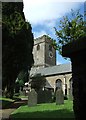
2

St Petroc's church, Padstow
The north side of the church, showing the double aisled layout typical of many Cornish churches.
Image: © Simon Huguet
Taken: 7 Aug 2008
0.09 miles
3
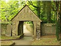
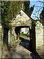
Lychgate, Padstow
The Victorian lychgate at the south entrance to the churchyard of Image "Timber frame infilled with slate ... a cambered inscribed bressumer with a chamfered soffit which is supported on jowled timber posts" http://www.britishlistedbuildings.co.uk/en-396237-lychgate-at-south-entrance-to-churchyard . The bressumer is the large crossbeam supporting the gable.
Image: © Derek Harper
Taken: 29 Apr 2011
0.09 miles
4
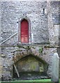
St Petroc's church, Padstow
An unusual combination of features on the north side of the tower. The niche may have once held a tomb? The base of the tower dates from the C12th.
Image: © Simon Huguet
Taken: 7 Aug 2008
0.10 miles
5
St Petroc's church, Padstow
The tower and south porch seen through the churchyard from Church lane. There has been a church on this site since time immemorial, but although the foot of the power is C12th and the majority of the church dates from the C15th.
Image: © Simon Huguet
Taken: 7 Aug 2008
0.10 miles
6
Lychgate to Padstow church
Lychgate to St Petroc's church in Padstow.
Image: © Philip Halling
Taken: 14 Mar 2016
0.10 miles
7
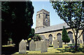
Padstow Church
The church is dedicated to St Petroc. Petroc was a Welsh nobleman who established a monastery here in the 6th century and is credited with converting King Constantine to Christianity. That church was destroyed by Viking raiders in the 10th century. The present church dates from the 15th century although the base of the tower is of earlier origin.
Image: © Stephen McKay
Taken: Unknown
0.11 miles
8
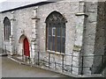
Padstow Church
The church in Padstow. In the bottom right of the image is located an Ordnance Survey flush bracket benchmark, reference number S6864.
Image: © Mat Tuck
Taken: 1 Apr 2016
0.11 miles
10
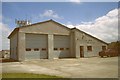
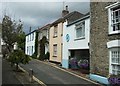
Padstow Fire Station
Padstow Fire Station, School Hill, Padstow, Cornwall.
Image: © Kevin Hale
Taken: 8 Jun 1997
0.11 miles