IMAGES TAKEN NEAR TO
Homer Park Road, PADSTOW, PL28 8QU
Introduction
This page details the photographs taken nearby to Homer Park Road, PL28 8QU by members of the Geograph project.
The Geograph project started in 2005 with the aim of publishing, organising and preserving representative images for every square kilometre of Great Britain, Ireland and the Isle of Man.

There are currently over 7.5m images from over14,400 individuals and you can help contribute to the project by visiting https://www.geograph.org.uk
Image Map (Loading...)


Getting Data...Please wait
Leaflet Map data © OpenStreetMap
Images are licensed for reuse under creativecommons.org/licenses/by-sa/2.0
Notes
- Clicking on the map will re-center to the selected point.
- The higher the marker number, the further away the image location is from the centre of the postcode.
Image Listing (33 Images Found)
Images are licensed for reuse under creativecommons.org/licenses/by-sa/2.0
Image
Details
Distance
2
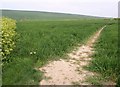
Path at Trevone
Footpath 532/11/1 sets out from the village of Trevone towards Tregerrin Barns.
Image: © Derek Harper
Taken: 29 Apr 2011
0.10 miles
3
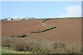
Fieldscape near Trevone
View from public footpath 532/11/1 between Trevone and Trethillick, across the valley to Porthmissen (skyline). The abrupt change in direction of the hedgerow is accounted for by another which has been removed (and used to continue across and up the field to the right).
Image: © Hugh Craddock
Taken: 9 Mar 2008
0.12 miles
4
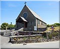
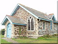
St Saviour's Church, Trevone
This church was built in 1959. The walls are local sandstone, from St Columb Downs. It is iron rich and the iron works outwards as the stone is weathered to give a hard casing. The roof is Delabole slate. It replaced a wooden mission church built in 1894. It is dedicated to St Saviour because there was a St Saviour's Chapel on what is now St Saviour's Point, on the Camel Estuary outside Padstow but inside the Doom Bar.
Image: © David Hawgood
Taken: 4 Sep 2005
0.13 miles
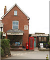
5

Former shop and cafe, Trevone
In a photo Image of this house in May 2009, the shopfront on the left of the phone box and letter box was "The Drawing Room" as a cafe, the smaller building on the right was the village store. There is now a Rick Stein shop nearby, specialising in food, but we could also buy newspapers.
Image: © David Hawgood
Taken: 19 Jun 2014
0.14 miles
7
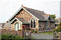
The Chapel, Trevone
Now a private dwelling named The Chapel, formerly a place of worship.
Image: © Andy F
Taken: 2 May 2009
0.14 miles
9
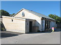
Rick Stein shop at Trevone Farm
The shop mainly sells food, but also has newspapers. Rick Stein also has self-catering houses for rent here.
Image: © David Hawgood
Taken: 19 Jun 2014
0.15 miles
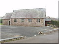
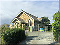
10
Trevone Methodist Chapel
In the centre of Trevone, away from the beach
Image: © David Hawgood
Taken: 4 Sep 2005
0.17 miles