IMAGES TAKEN NEAR TO
Towan, St. Merryn, PADSTOW, PL28 8PJ
Introduction
This page details the photographs taken nearby to PL28 8PJ by members of the Geograph project.
The Geograph project started in 2005 with the aim of publishing, organising and preserving representative images for every square kilometre of Great Britain, Ireland and the Isle of Man.

There are currently over 7.5m images from over14,400 individuals and you can help contribute to the project by visiting https://www.geograph.org.uk
Image Map
Images are licensed for reuse under creativecommons.org/licenses/by-sa/2.0
Notes
- Clicking on the map will re-center to the selected point.
- The higher the marker number, the further away the image location is from the centre of the postcode.
Image Listing (5 Images Found)
Images are licensed for reuse under creativecommons.org/licenses/by-sa/2.0
Image
Details
Distance
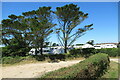
2

Towan Pond
A sign by the pond says that the council is working to eliminate invasive weeds.
Image: © David Hawgood
Taken: 3 Sep 2005
0.09 miles
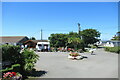
3

Towan village green
Looking north-east, just by the pond
Image: © David Hawgood
Taken: 3 Sep 2005
0.09 miles