IMAGES TAKEN NEAR TO
St. Merryn, PADSTOW, PL28 8NR
Introduction
This page details the photographs taken nearby to PL28 8NR by members of the Geograph project.
The Geograph project started in 2005 with the aim of publishing, organising and preserving representative images for every square kilometre of Great Britain, Ireland and the Isle of Man.

There are currently over 7.5m images from over14,400 individuals and you can help contribute to the project by visiting https://www.geograph.org.uk
Image Map (Loading...)


Getting Data...Please wait
Leaflet Map data © OpenStreetMap
Images are licensed for reuse under creativecommons.org/licenses/by-sa/2.0
Notes
- Clicking on the map will re-center to the selected point.
- The higher the marker number, the further away the image location is from the centre of the postcode.
Image Listing (12 Images Found)
Images are licensed for reuse under creativecommons.org/licenses/by-sa/2.0
Image
Details
Distance
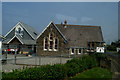
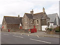
2
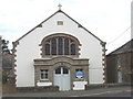
St Merryn Methodist Church
Next to the school.
Image: © David Hawgood
Taken: 18 Aug 2006
0.03 miles
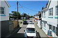
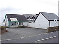
4
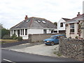
Bungalows in St Merryn
On the road to Porthcothan and Newquay.
Image: © David Hawgood
Taken: 18 Aug 2006
0.06 miles
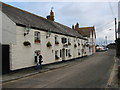
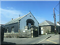
5
Former Wesleyan chapel
Now St Merryn Parish Hall and Institute
Image: © Paul Barnett
Taken: 19 Jul 2019
0.09 miles
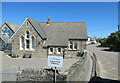
6
St Merryn School
Another photo Image shows the playground end of the school.
Image: © David Hawgood
Taken: 18 Aug 2006
0.10 miles
7
Veterinary surgery, St Merryn
Opposite the school and methodist church.
Image: © David Hawgood
Taken: 18 Aug 2006
0.10 miles