IMAGES TAKEN NEAR TO
Sarahs Meadow, PADSTOW, PL28 8LX
Introduction
This page details the photographs taken nearby to Sarahs Meadow, PL28 8LX by members of the Geograph project.
The Geograph project started in 2005 with the aim of publishing, organising and preserving representative images for every square kilometre of Great Britain, Ireland and the Isle of Man.

There are currently over 7.5m images from over14,400 individuals and you can help contribute to the project by visiting https://www.geograph.org.uk
Image Map (Loading...)


Getting Data...Please wait
Leaflet Map data © OpenStreetMap
Images are licensed for reuse under creativecommons.org/licenses/by-sa/2.0
Notes
- Clicking on the map will re-center to the selected point.
- The higher the marker number, the further away the image location is from the centre of the postcode.
Image Listing (29 Images Found)
Images are licensed for reuse under creativecommons.org/licenses/by-sa/2.0
Image
Details
Distance
1
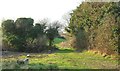
Track at Dennis Cove
Not a right of way, this track follows the valley upstream a little way to reach a field.
Image: © Derek Harper
Taken: 20 Jan 2017
0.07 miles
2
Saints' Way at Dennis Cove
A reverse view of Image], with the Way heading up Dennis Lane into Padstow.
Image: © Derek Harper
Taken: 20 Jan 2017
0.07 miles
3
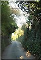
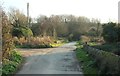
Dennis Lane
The Saints' Way leaves Padstow down this no through road to Dennis Cove.
Image: © Derek Harper
Taken: 20 Jan 2017
0.07 miles
4
Saints' Way at Dennis Cove
The Way follows a bend as footpath 532 8/2 joins the lane.
Image: © Derek Harper
Taken: 20 Jan 2017
0.08 miles
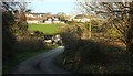
5
Saints' Way at Dennis Cove
Dennis lane ends here as far as vehicular traffic goes, but the Way continues along this track, while a footpath to the left links to the Camel Trail.
Image: © Derek Harper
Taken: 20 Jan 2017
0.09 miles
6
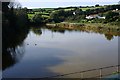
Pool beside the Camel Trail
This pool lies beside the Camel Trail cycleway just south of Padstow.
Image: © Andy F
Taken: 1 May 2009
0.12 miles
7
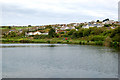
Dennis Cove
This is one of the smaller tidal creeks which the railway line, which now forms the Camel Trail, has to cross. Here a weir has been built just in front of where I am standing which has turned this muddy tidal creek into a freshwater lake.
Image: © Tony Atkin
Taken: 17 Oct 2009
0.13 miles
8
Saints' Way approaching Padstow
Looking left from Image], with overlap. The Way follows footpath 532 8/2 down past the farm towards Dennis Cove and then up through suburbs into Padstow.
Image: © Derek Harper
Taken: 20 Jan 2017
0.15 miles
9
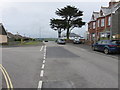
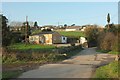
Sarah's Lane, Padstow
The River Camel can just be seen in the distance.
Image: © Richard Rogerson
Taken: 6 Jul 2015
0.16 miles
10
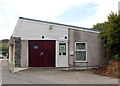
Padstow Sea Cadets HQ
This building stands beside the Camel Trail on the foreshore just south of Padstow.
Image: © Andy F
Taken: 1 May 2009
0.16 miles