IMAGES TAKEN NEAR TO
Porthcothan Bay, PADSTOW, PL28 8LP
Introduction
This page details the photographs taken nearby to PL28 8LP by members of the Geograph project.
The Geograph project started in 2005 with the aim of publishing, organising and preserving representative images for every square kilometre of Great Britain, Ireland and the Isle of Man.

There are currently over 7.5m images from over14,400 individuals and you can help contribute to the project by visiting https://www.geograph.org.uk
Image Map
Images are licensed for reuse under creativecommons.org/licenses/by-sa/2.0
Notes
- Clicking on the map will re-center to the selected point.
- The higher the marker number, the further away the image location is from the centre of the postcode.
Image Listing (34 Images Found)
Images are licensed for reuse under creativecommons.org/licenses/by-sa/2.0
Image
Details
Distance
3
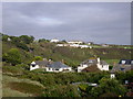
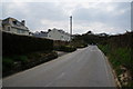
Porthcothan
Looking inland from the South West Coast Path on the south side of Porthcothan bay. The Tredrea Inn, in adjacent gridsquare Image, is the low flat building on the rise of the hill.
Image: © Val Pollard
Taken: 5 Oct 2009
0.10 miles
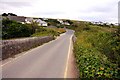
5

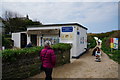
Porthcothan from the coast path
Looking inland towards the hamlet of Porthcothan from the coast path.
Image: © Val Pollard
Taken: 16 Sep 2011
0.11 miles
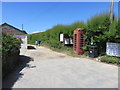
9
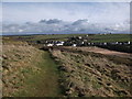
The coast path at Porthcothan
Bear's Downs wind farm in the background.
Image: © John Brightley
Taken: 3 Apr 2010
0.12 miles