IMAGES TAKEN NEAR TO
PADSTOW, PL28 8JA
Introduction
This page details the photographs taken nearby to PL28 8JA by members of the Geograph project.
The Geograph project started in 2005 with the aim of publishing, organising and preserving representative images for every square kilometre of Great Britain, Ireland and the Isle of Man.

There are currently over 7.5m images from over14,400 individuals and you can help contribute to the project by visiting https://www.geograph.org.uk
Image Map
Images are licensed for reuse under creativecommons.org/licenses/by-sa/2.0
Notes
- Clicking on the map will re-center to the selected point.
- The higher the marker number, the further away the image location is from the centre of the postcode.
Image Listing (2 Images Found)
Images are licensed for reuse under creativecommons.org/licenses/by-sa/2.0
Image
Details
Distance
1
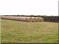
Straw and stubble, field near Trevone
This field is by the road from Padstow and the B3276 to Harlyn Bay. Wheat is sprouting through the stubble, and round bales of straw have been collected at the side of the field. There are piles of straw bales all over the countryside.
Image: © David Hawgood
Taken: 4 Sep 2005
0.09 miles
2
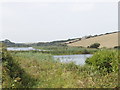
Pools by Trenearne Bridge, near St Merryn
The road from Padstow to St Merryn goes steeply down to the stream which reaches the sea at Harlyn Bay. These pools are just below the bridge.
Image: © David Hawgood
Taken: 4 Sep 2005
0.18 miles