IMAGES TAKEN NEAR TO
PADSTOW, PL28 8HR
Introduction
This page details the photographs taken nearby to PL28 8HR by members of the Geograph project.
The Geograph project started in 2005 with the aim of publishing, organising and preserving representative images for every square kilometre of Great Britain, Ireland and the Isle of Man.

There are currently over 7.5m images from over14,400 individuals and you can help contribute to the project by visiting https://www.geograph.org.uk
Image Map (Loading...)


Getting Data...Please wait
Leaflet Map data © OpenStreetMap
Images are licensed for reuse under creativecommons.org/licenses/by-sa/2.0
Notes
- Clicking on the map will re-center to the selected point.
- The higher the marker number, the further away the image location is from the centre of the postcode.
Image Listing (43 Images Found)
Images are licensed for reuse under creativecommons.org/licenses/by-sa/2.0
Image
Details
Distance
3
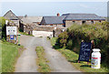
Cream teas at Lellizzick Farm
The entrance to Lellizzick Farm where cream teas are served in a secluded garden.
Image: © Andy F
Taken: 2 May 2009
0.01 miles
4
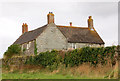
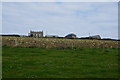
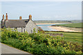
Lellizzick farmhouse from the southeast
The farmhouse lies south of the lane to Hawkers Cove. The owners offer luxury B&B accommodation.
Image: © Andy F
Taken: 23 Aug 2009
0.02 miles
5
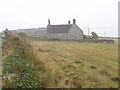
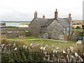
Lellizzick
This is a farm on Stepper Point
Image: © David Hawgood
Taken: 4 Sep 2005
0.02 miles
6
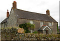
Lellizzick farmhouse from the south
The farmhouse lies south of the lane to Hawkers Cove. The owners offer luxury B&B accommodation.
Image: © Andy F
Taken: 23 Aug 2009
0.02 miles
7
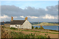
Lellizzick farmhouse from the west
Looking west towards the farmhouse which lies south of the lane to Hawkers Cove. The owners offer luxury B&B accommodation. Brase Hill is in the middle distance on the east side of the River Camel estuary.
Image: © Andy F
Taken: 22 Aug 2009
0.02 miles
8
Lellizzick view
Looking south-east from the lane at Lellizzick with Lellizick Farm in the foreground. The beach on the far side of the River Camel estuary stretches from Rock to Brae Hill; the beach nearer the camera is Tregirls beach.
Image: © Andy F
Taken: 2 May 2009
0.02 miles
9
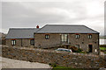
Barn conversion at Lellizzick
This converted barn is named 'West Lellizzick'
Image: © Andy F
Taken: 22 Aug 2009
0.03 miles