IMAGES TAKEN NEAR TO
Nutwell Close, PADSTOW, PL28 8GH
Introduction
This page details the photographs taken nearby to Nutwell Close, PL28 8GH by members of the Geograph project.
The Geograph project started in 2005 with the aim of publishing, organising and preserving representative images for every square kilometre of Great Britain, Ireland and the Isle of Man.

There are currently over 7.5m images from over14,400 individuals and you can help contribute to the project by visiting https://www.geograph.org.uk
Image Map (Loading...)


Getting Data...Please wait
Leaflet Map data © OpenStreetMap
Images are licensed for reuse under creativecommons.org/licenses/by-sa/2.0
Notes
- Clicking on the map will re-center to the selected point.
- The higher the marker number, the further away the image location is from the centre of the postcode.
Image Listing (14 Images Found)
Images are licensed for reuse under creativecommons.org/licenses/by-sa/2.0
Image
Details
Distance
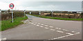
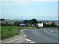
2
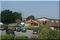
Padstow : A389
The A389 heading into Padstow.
Image: © Lewis Clarke
Taken: 2 Oct 2022
0.12 miles
3
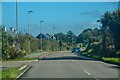
The edge of Padstow
Houses at Polpennic Drive on the A39.
Image: © Robert Ashby
Taken: 18 Aug 2014
0.12 miles
4
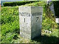
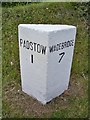
Old Milestone by the B3276, south of Trecerus Farm
Carved stone post by the B3276, in parish of PADSTOW (NORTH CORNWALL District), South of Trecerus Farm, Newquay road by-passing Padstow, on West side of road. Erected by the Local Highways Board in the 19th century.
Inscription reads:-
: PADSTOW / 1 : : WADEBRIDGE / 7 :
Grade II listed.
List Entry Number: 1211505 https://historicengland.org.uk/listing/the-list/list-entry/1211505
Milestone Society National ID: CW_PSWB01.
Image: © Rosy Hanns
Taken: 11 May 2019
0.13 miles
5
Old Milestone by the B3276, south of Trecerus Farm
Carved stone post by the B3276, in parish of PADSTOW (NORTH CORNWALL District), South of Trecerus Farm, Newquay road by-passing Padstow, on West side of road. Erected by the Local Highways Board in the 19th century.
Inscription reads:-
: PADSTOW / 1 : : WADEBRIDGE / 7 :
Grade II Listed. List Entry Number: 1211505
https://historicengland.org.uk/listing/the-list/list-entry/1211505
Milestone Society National ID: CW_PSWB01.
Image: © Ian Thompson
Taken: 10 Dec 2017
0.13 miles
7
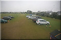
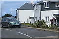
Park and ride not the classic tourist view of Padstow
Padstow operates a good park and ride. The main car parks were well full at Padstow but this late afternoon view shows that many had gone home due to the heavy rain so few cars remained in the park and ride field.
Image: © roger geach
Taken: 3 Sep 2011
0.14 miles
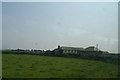
8
Junction west of Padstow
The B3276 heads north from the junction with the A389 and Green Lane (left - Image]). Oddly, and possibly confusingly, the B3276 manages to meet the A389 at three different places around Padstow. You may also wonder why the 40mph speed limit only seems to last for about 7 metres, but I think the limit is for the benefit of traffic following the main road round to the right here.
Image: © Derek Harper
Taken: 3 Feb 2018
0.19 miles
10
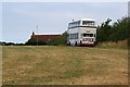
A Bus in a Field
I have no idea what this double decker is doing parked on the edge of this field. It seems incongruous as the company whose logo adorns the bus has not run services in this part of the country for at least three years.
Image: © Tony Atkin
Taken: 22 Jul 2006
0.20 miles