IMAGES TAKEN NEAR TO
Fentonluna Gardens, High Street, PADSTOW, PL28 8BW
Introduction
This page details the photographs taken nearby to Fentonluna Gardens, High Street, PL28 8BW by members of the Geograph project.
The Geograph project started in 2005 with the aim of publishing, organising and preserving representative images for every square kilometre of Great Britain, Ireland and the Isle of Man.

There are currently over 7.5m images from over14,400 individuals and you can help contribute to the project by visiting https://www.geograph.org.uk
Image Map (Loading...)


Getting Data...Please wait
Leaflet Map data © OpenStreetMap
Images are licensed for reuse under creativecommons.org/licenses/by-sa/2.0
Notes
- Clicking on the map will re-center to the selected point.
- The higher the marker number, the further away the image location is from the centre of the postcode.
Image Listing (217 Images Found)
Images are licensed for reuse under creativecommons.org/licenses/by-sa/2.0
Image
Details
Distance
1
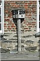
Mile Post 259 1/4
This is the highest milepost on the London & South Western Railway, miles from Waterloo. It was originally at the station in the adjacent square but is now outside a pub near the harbour.
Image: © Gareth Foster
Taken: 25 Jun 2004
0.02 miles
2
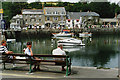
Bench with a view
A good vantage point for people watching, at Padstow harbour.
Image: © Roger Cornfoot
Taken: Unknown
0.02 miles
3
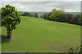
Deer park, Prideaux Place
"The park was landscaped by Humphrey Prideaux c 1750" https://www.heritagegateway.org.uk/Gateway/Results_Single.aspx?uid=1212008&resourceID=5 .
Image: © Derek Harper
Taken: 17 May 2021
0.04 miles
4
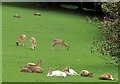
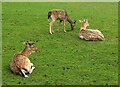
Deer at Prideaux Place
A detail of Image The paler animals are part of a new breeding programme. "The aim is to get a paler colour fallow deer so much admired in park deer. This gentle process will take many years" https://prideauxplace.co.uk/the-deer-park/ .
Image: © Derek Harper
Taken: 17 May 2021
0.05 miles
5
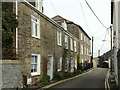
Houses on High Street, Padstow
The four-bay three-storey building is listed as Tregea, now the Padstow Townhouse https://historicengland.org.uk/listing/the-list/list-entry/1289832 . The two nearer attached houses are described at https://historicengland.org.uk/listing/the-list/list-entry/1211853 .
Image: © Derek Harper
Taken: 6 Feb 2019
0.05 miles
6
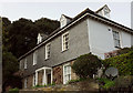
House on High Street, Padstow
The uppermost house on the north side of the street, by the junction with the lane to Tregirls. Listed and described at https://historicengland.org.uk/listing/the-list/list-entry/1289821 . The wood in the background is part of those surrounding Prideaux Place.
Image: © Derek Harper
Taken: 6 Feb 2019
0.05 miles
7
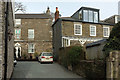
Houses in Padstow
A view from High Street, which is the address of the house on the right; the one on the left, however, belongs to Fentonluna Lane, on the other side.
Image: © Derek Harper
Taken: 6 Feb 2019
0.05 miles
8
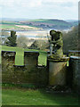
Contemplative statue, Prideaux Place
I'm not sure what this stone fellow is up to, but he appears to be checking out his left foot - he's probably picked up a thorn; well that'll teach him to go wandering around the garden bare-foot. Mind you, as he doesn't appear to be wearing a lot, perhaps he should be glad that it's just his foot ...
Behind him can be seen the sands and water of the Camel estuary.
Image: © Rob Farrow
Taken: 12 Apr 2012
0.06 miles
9
Deer, Prideaux Place
Fallow deer close to the house https://www.heritagegateway.org.uk/Gateway/Results_Single.aspx?uid=1212008&resourceID=5 .
Image: © Derek Harper
Taken: 17 May 2021
0.06 miles
10
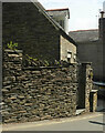
Wall, Church Street, Padstow
The lower end of the fine stretch of wall shown in Image This is on the B3276.
Image: © Derek Harper
Taken: 17 May 2021
0.06 miles