IMAGES TAKEN NEAR TO
Penrose, WADEBRIDGE, PL27 7TD
Introduction
This page details the photographs taken nearby to PL27 7TD by members of the Geograph project.
The Geograph project started in 2005 with the aim of publishing, organising and preserving representative images for every square kilometre of Great Britain, Ireland and the Isle of Man.

There are currently over 7.5m images from over14,400 individuals and you can help contribute to the project by visiting https://www.geograph.org.uk
Image Map (Loading...)


Getting Data...Please wait
Leaflet Map data © OpenStreetMap
Images are licensed for reuse under creativecommons.org/licenses/by-sa/2.0
Notes
- Clicking on the map will re-center to the selected point.
- The higher the marker number, the further away the image location is from the centre of the postcode.
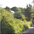
Image Listing (3 Images Found)
Images are licensed for reuse under creativecommons.org/licenses/by-sa/2.0
Image
Details
Distance
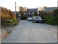
1
Lewidden, near Penrose
Just a few houses in a lush valley.
Image: © David Hawgood
Taken: 3 Sep 2005
0.01 miles
2
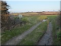
Track and footpath at Penrose
This track and footpath leads to the site of the former St Merryn airfield which closed in the 1950s.
Image: © Philip Halling
Taken: 14 Mar 2016
0.18 miles