IMAGES TAKEN NEAR TO
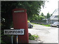
Rumford, WADEBRIDGE, PL27 7SU
Introduction
This page details the photographs taken nearby to PL27 7SU by members of the Geograph project.
The Geograph project started in 2005 with the aim of publishing, organising and preserving representative images for every square kilometre of Great Britain, Ireland and the Isle of Man.

There are currently over 7.5m images from over14,400 individuals and you can help contribute to the project by visiting https://www.geograph.org.uk
Image Map (Loading...)


Getting Data...Please wait
Leaflet Map data © OpenStreetMap
Images are licensed for reuse under creativecommons.org/licenses/by-sa/2.0
Notes
- Clicking on the map will re-center to the selected point.
- The higher the marker number, the further away the image location is from the centre of the postcode.
Image Listing (6 Images Found)
Images are licensed for reuse under creativecommons.org/licenses/by-sa/2.0
Image
Details
Distance
2
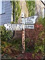
Direction Sign - Signpost in Rumford
Raised finial; by the UC road, in parish of St Eval (North Cornwall District), in Rumford beside Old Sunday School, at road edge in garden.
To be surveyed
Milestone Society National ID: CW_SW8970
Image: © Milestone Society
Taken: Unknown
0.07 miles
4
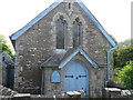
Former Rumford Wesleyan Methodist Chapel
Image: © Paul Barnett
Taken: 1 Jan 2019
0.12 miles
6
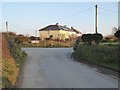
Dolgey Post
Dolgey Post near Rumford.
Image: © Philip Halling
Taken: 14 Mar 2016
0.18 miles