IMAGES TAKEN NEAR TO
St. Issey, WADEBRIDGE, PL27 7RG
Introduction
This page details the photographs taken nearby to PL27 7RG by members of the Geograph project.
The Geograph project started in 2005 with the aim of publishing, organising and preserving representative images for every square kilometre of Great Britain, Ireland and the Isle of Man.

There are currently over 7.5m images from over14,400 individuals and you can help contribute to the project by visiting https://www.geograph.org.uk
Image Map
Images are licensed for reuse under creativecommons.org/licenses/by-sa/2.0
Notes
- Clicking on the map will re-center to the selected point.
- The higher the marker number, the further away the image location is from the centre of the postcode.
Image Listing (5 Images Found)
Images are licensed for reuse under creativecommons.org/licenses/by-sa/2.0
Image
Details
Distance
1
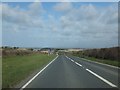
The Atlantic Highway near Hawksland
This is the highest point on the gentle hill between West Park Farm and Hals Grave, giving views towards Wadebridge and the coastal hills beyond
Image: © David Smith
Taken: 8 Mar 2012
0.15 miles
2
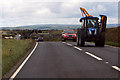
The A39
Heading north-east towards Whitecross.
Image: © Robert Ashby
Taken: 21 Aug 2014
0.16 miles
3
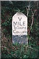
Old Milestone by the A39, south of Hawksland
Carved stone post by the A39, in parish of ST BREOCK (NORTH CORNWALL District), 250m South of Hawksland; 10m from Hawksland turning, by the road, on East side of road. St Columb stone, erected by the Camelford, Wadebridge & St Columb turnpike trust in the 18th century.
Inscription reads:-
V
MILE
To Saint
COLUMB
Grade II Listed. List Entry Number:1212670
https://historicengland.org.uk/listing/the-list/list-entry/1212670
Milestone Society National ID: CW_SCWB05.
Image: © Ian Thompson
Taken: 10 Dec 2017
0.18 miles
4

Old Milestone by the A39, south of Hawksland
Carved stone post by the A39, in parish of ST BREOCK (NORTH CORNWALL District), 250m South of Hawksland; 10m from Hawksland turning, by the road, on East side of road. St Columb stone, erected by the Camelford, Wadebridge & St Columb turnpike trust in the 18th century.
Inscription reads:-
V
MILE
To Saint
COLUMB
Carved benchmark and rivet on top.
Grade II listed.
List Entry Number: 1212670 https://historicengland.org.uk/listing/the-list/list-entry/1212670
Milestone Society National ID: CW_SCWB05
Image: © Rosy Hanns
Taken: 11 May 2019
0.18 miles
5
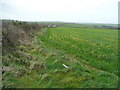
Field next to the A39
Looking south with a glimpse over the hedge to see traffic on the Atlantic Highway.
Image: © Jonathan Billinger
Taken: 5 Feb 2008
0.20 miles