IMAGES TAKEN NEAR TO
Park En Vine, WADEBRIDGE, PL27 7QG
Introduction
This page details the photographs taken nearby to Park En Vine, PL27 7QG by members of the Geograph project.
The Geograph project started in 2005 with the aim of publishing, organising and preserving representative images for every square kilometre of Great Britain, Ireland and the Isle of Man.

There are currently over 7.5m images from over14,400 individuals and you can help contribute to the project by visiting https://www.geograph.org.uk
Image Map (Loading...)


Getting Data...Please wait
Leaflet Map data © OpenStreetMap
Images are licensed for reuse under creativecommons.org/licenses/by-sa/2.0
Notes
- Clicking on the map will re-center to the selected point.
- The higher the marker number, the further away the image location is from the centre of the postcode.
Image Listing (21 Images Found)
Images are licensed for reuse under creativecommons.org/licenses/by-sa/2.0
Image
Details
Distance
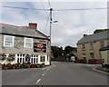
1
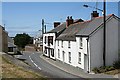
St Issey Village
Taken from the edge of the churchyard.
Image: © Tony Atkin
Taken: 22 Jul 2006
0.11 miles
2
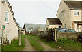
Footpath, St Issey
Footpath 541 1/1 leaves the A389 and works its way past the houses before dividing for Trevance or the lane to Tregonce.
Image: © Derek Harper
Taken: 6 Feb 2019
0.11 miles
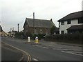
3
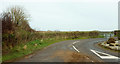
Banjo Lane, St Issey
Leaving the A389 at the western edge of the village. In the distance is a terrace of four houses where the winding lane meets the lane to Sea Mills.
Image: © Derek Harper
Taken: 6 Feb 2019
0.12 miles
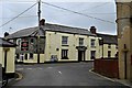
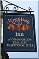
9
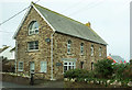
Former chapel, St Issey
Also shown in Image Probably early C20.
Image: © Derek Harper
Taken: 6 Feb 2019
0.15 miles
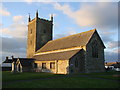
10
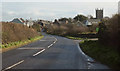
Approaching St Issey
On the A389. For the church, dedicated to St Ida, see http://www.geograph.org.uk/search.php?i=91340496 ; the listed building description is at https://historicengland.org.uk/listing/the-list/list-entry/1212700 .
Image: © Derek Harper
Taken: 7 Feb 2019
0.15 miles