IMAGES TAKEN NEAR TO
St. Breock, WADEBRIDGE, PL27 7LL
Introduction
This page details the photographs taken nearby to PL27 7LL by members of the Geograph project.
The Geograph project started in 2005 with the aim of publishing, organising and preserving representative images for every square kilometre of Great Britain, Ireland and the Isle of Man.

There are currently over 7.5m images from over14,400 individuals and you can help contribute to the project by visiting https://www.geograph.org.uk
Image Map (Loading...)


Getting Data...Please wait
Leaflet Map data © OpenStreetMap
Images are licensed for reuse under creativecommons.org/licenses/by-sa/2.0
Notes
- Clicking on the map will re-center to the selected point.
- The higher the marker number, the further away the image location is from the centre of the postcode.
Image Listing (13 Images Found)
Images are licensed for reuse under creativecommons.org/licenses/by-sa/2.0
Image
Details
Distance
1
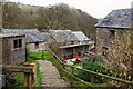
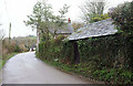
Pawton Mill
Extensive work being carried out at the mill, which was "derelict" when the listed building description was written in 1988 https://historicengland.org.uk/listing/the-list/list-entry/1159554 . The mill stands close to the Polmorla Brook. The part on the left beside the waterwheel (out of sight), Pawton Mill Cottage, is available to let.
Image: © Derek Harper
Taken: 7 Feb 2019
0.01 miles
2
Pawton Mill
The far end of the building https://historicengland.org.uk/listing/the-list/list-entry/1159554 shown in Image], seen from the lane shown in Image
Image: © Derek Harper
Taken: 7 Feb 2019
0.01 miles
3
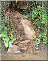
Collapsing bank, Pawton Mill
Slate has slipped from the wall by the lane past the mill.
Image: © Derek Harper
Taken: 7 Feb 2019
0.02 miles
4
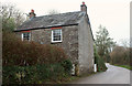
House at Pawton Mill
Variously named Pawton Millhouse (listed building description at https://historicengland.org.uk/listing/the-list/list-entry/1327918 ) and Pawton Mill Farmhouse (OS map); the latter seems to be the current correct version. It is used as a holiday cottage. "Unaltered and complete front and rear elevations."
Image: © Derek Harper
Taken: 7 Feb 2019
0.02 miles
5
Lane at Pawton Mill
Beyond the outbuilding is a house mapped as Pawton Mill Farmhouse and listed as Pawton Millhouse https://historicengland.org.uk/listing/the-list/list-entry/1327918 : "Unaltered and complete front and rear elevations." A clearer image is at Image The mill itself is across the lane below on the left.
Image: © Derek Harper
Taken: 7 Feb 2019
0.04 miles
6

Waterfall, Pawton Mill
A tiny tributary tumbles down a miniature waterfall before running beneath the lane past the mill.
Image: © Derek Harper
Taken: 7 Feb 2019
0.05 miles
7
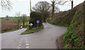
Lane at Pawton Mill
The turning on the left is the drive down to the mill - see Image
Image: © Derek Harper
Taken: 7 Feb 2019
0.05 miles
8

Hens, Pawton Mill
In a field that slopes down to the Polmorla Brook, beside which are some solar panels.
Image: © Derek Harper
Taken: 7 Feb 2019
0.05 miles
9
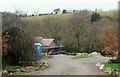
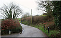
Lane to Hay
Mapped as a public access route, this no through road climbs from the Polmorla valley road to the farm at Hay and then continues up for a further 400 metres.
Image: © Derek Harper
Taken: 7 Feb 2019
0.08 miles
10
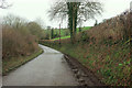
Lane along Polmorla valley
Running below the lane to Hay shown at Image
Image: © Derek Harper
Taken: 7 Feb 2019
0.13 miles