IMAGES TAKEN NEAR TO
Burlawn, WADEBRIDGE, PL27 7LB
Introduction
This page details the photographs taken nearby to PL27 7LB by members of the Geograph project.
The Geograph project started in 2005 with the aim of publishing, organising and preserving representative images for every square kilometre of Great Britain, Ireland and the Isle of Man.

There are currently over 7.5m images from over14,400 individuals and you can help contribute to the project by visiting https://www.geograph.org.uk
Image Map (Loading...)


Getting Data...Please wait
Leaflet Map data © OpenStreetMap
Images are licensed for reuse under creativecommons.org/licenses/by-sa/2.0
Notes
- Clicking on the map will re-center to the selected point.
- The higher the marker number, the further away the image location is from the centre of the postcode.
Image Listing (14 Images Found)
Images are licensed for reuse under creativecommons.org/licenses/by-sa/2.0
Image
Details
Distance
1
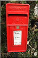
Postbox, Burlawn
The Elizabeth II postbox, number PL27 163, is shown in Image
Image: © Derek Harper
Taken: 24 Jan 2017
0.02 miles
2
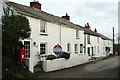
Elm Terrace, Burlawn
The Elizabeth II postbox PL27 163 stands beside the former post office, currently for sale.
Image: © Derek Harper
Taken: 24 Jan 2017
0.02 miles
3
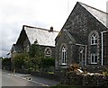
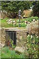
Converted Schoolhouse and Chapel
Two buildings almost identical in aspect, one was a chapel, the other a schoolhouse. Both are now converted to residential usage.
Image: © Tony Atkin
Taken: 22 Aug 2006
0.06 miles
4
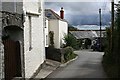
Burlawn Village
Houses at the T junction which is the village centre.
Image: © Tony Atkin
Taken: 22 Aug 2006
0.13 miles
5
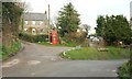
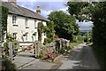
Cottage and phone box, Burlawn
To the left of the cottage is the track mentioned at Image], along which is the unreachable footpath 534 5/1.
Image: © Derek Harper
Taken: 24 Jan 2017
0.13 miles
6
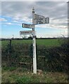
Direction Sign ? Signpost at Pengelly Cross
Located on the north side of Pengelly Cross, northwest of Burlawn in St Breock parish. 4 arms and cone finial. A wooden predecessor can be seen in https://www.geograph.org.uk/photo/5430914.
Milestone Society National ID: CW_SW9970
Image: © I Williams
Taken: Unknown
0.14 miles
7
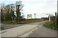
Pengelly Cross
A crossroads at the northern edge of Burlawn, named after Pengelly Farm, a few metres along the lane on the left which is signposted "Polmorla". The farm is also advertised here by signs for shooting equipment and B&B.
Image: © Derek Harper
Taken: 24 Jan 2017
0.14 miles
9
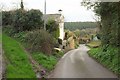
Lane and track, Burlawn
The lane through the village drops past Hustyn Cottage into a deep wooded valley.
Image: © Derek Harper
Taken: 24 Jan 2017
0.16 miles