IMAGES TAKEN NEAR TO
Trevanion, WADEBRIDGE, PL27 7JY
Introduction
This page details the photographs taken nearby to PL27 7JY by members of the Geograph project.
The Geograph project started in 2005 with the aim of publishing, organising and preserving representative images for every square kilometre of Great Britain, Ireland and the Isle of Man.

There are currently over 7.5m images from over14,400 individuals and you can help contribute to the project by visiting https://www.geograph.org.uk
Image Map (Loading...)


Getting Data...Please wait
Leaflet Map data © OpenStreetMap
Images are licensed for reuse under creativecommons.org/licenses/by-sa/2.0
Notes
- Clicking on the map will re-center to the selected point.
- The higher the marker number, the further away the image location is from the centre of the postcode.
Image Listing (8 Images Found)
Images are licensed for reuse under creativecommons.org/licenses/by-sa/2.0
Image
Details
Distance
1
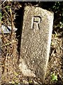
Old Boundary Marker
Municipal Boundary Marker on the north east side of Trevanion Road to the south of Wadebridge. This was the boundary of St Columb Major Rural District and Wadebridge Urban District between 1894 and 1934, and is now the boundary between St Breock and Wadebridge parishes. Inscribed R (for St Columb Major RD) and U (for Wadebridge UD) on adjacent faces.
Milestone Society National ID: CW_WADSBR03pb
Image: © R Hanns
Taken: 29 Sep 2019
0.08 miles
3
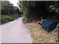
A place to sit and a grit bin for the winter
Image: © Rob Purvis
Taken: 6 Aug 2014
0.09 miles
4
Path to Treneague
A reverse view of Image with footpath 560 8/1 approaching the junction with a field path and Trevanion Road.
Image: © Derek Harper
Taken: 24 Jan 2017
0.10 miles
5
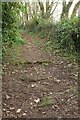
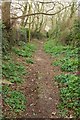
Path to Treneague
Footpath 560 8/1 follows this tree-lined track from Trevanion Road.
Image: © Derek Harper
Taken: 24 Jan 2017
0.10 miles
6
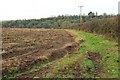
Field east of Polmorla
From footpath 560 8/1, looking towards the Treguddick Stream valley and the wooded slopes of Coronation Park.
Image: © Derek Harper
Taken: 24 Jan 2017
0.12 miles
7
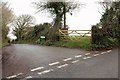
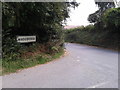
Treraven Lane
A no through road off a lane south of Wadebridge, carrying the parish boundary between Wadebridge (left) and St Breock.
Image: © Derek Harper
Taken: 24 Jan 2017
0.17 miles
8
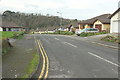
Treneague Park. Wadebridge
Seen from its junction with Trevanion Road. Across the Treguddick Stream valley are the wooded slopes of Coronation Park.
Image: © Derek Harper
Taken: 24 Jan 2017
0.17 miles