IMAGES TAKEN NEAR TO
West Hill, WADEBRIDGE, PL27 7ES
Introduction
This page details the photographs taken nearby to West Hill, PL27 7ES by members of the Geograph project.
The Geograph project started in 2005 with the aim of publishing, organising and preserving representative images for every square kilometre of Great Britain, Ireland and the Isle of Man.

There are currently over 7.5m images from over14,400 individuals and you can help contribute to the project by visiting https://www.geograph.org.uk
Image Map (Loading...)


Getting Data...Please wait
Leaflet Map data © OpenStreetMap
Images are licensed for reuse under creativecommons.org/licenses/by-sa/2.0
Notes
- Clicking on the map will re-center to the selected point.
- The higher the marker number, the further away the image location is from the centre of the postcode.
Image Listing (15 Images Found)
Images are licensed for reuse under creativecommons.org/licenses/by-sa/2.0
Image
Details
Distance
1
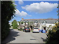
West Hill houses and gardens, Wadebridge
This used to be the main road through Wadebridge, there is now a bypass - the bridge over the Camel is in the photo beyond the houses on the left. Photo taken looking North-east from the upper window of a house.
Image: © David Hawgood
Taken: 4 Sep 2005
0.09 miles
2
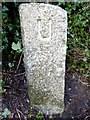
Old Boundary Marker
Municipal Boundary Marker on the south west side of the unclassified Trevanson Road. This was the boundary of St Columb Major Rural District and Wadebridge Urban District between 1894 and 1934, and is now the boundary between St Breock and Wadebridge parishes. Inscribed R (for St Columb Major RD) and U (for Wadebridge UD) on adjacent faces.
Milestone Society National ID: CW_WADSBR04pb
Image: © R Hanns
Taken: 29 Sep 2019
0.12 miles
3
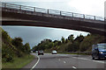
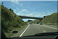
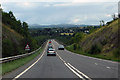
The A39
Passing just north of Wadebridge the bridge carries the B3314 into the town.
Image: © Robert Ashby
Taken: 21 Aug 2014
0.14 miles
4
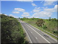
A39, Trevanson
The A39 Atlantic Highway climbing away from the Camel bridge west of Wadebridge
Image: © Pierre Terre
Taken: 2 Aug 2005
0.14 miles
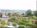
7
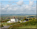
Wadebridge, Tesco store view
This must be one of the finest views from a supermarket car park anywhere in England. Looking north-east from Tesco's carpark in Wadebridge with the two Bodmin Moor peaks of Rough Tor (left) and Brown Willy (right) visible on the skyline. In the foreground, the old A39 (now bypassed) runs down the hill into Wadebridge.
Image: © Andy F
Taken: 30 Apr 2009
0.16 miles
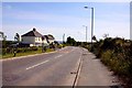
9
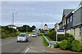
Wadebridge Travelodge
Conveniently located close to the A39 with a pub on the same site and a large supermarket within easy walking distance.
Image: © Mary and Angus Hogg
Taken: 28 Jun 2016
0.16 miles