IMAGES TAKEN NEAR TO
Hill Park, WADEBRIDGE, PL27 6UL
Introduction
This page details the photographs taken nearby to Hill Park, PL27 6UL by members of the Geograph project.
The Geograph project started in 2005 with the aim of publishing, organising and preserving representative images for every square kilometre of Great Britain, Ireland and the Isle of Man.

There are currently over 7.5m images from over14,400 individuals and you can help contribute to the project by visiting https://www.geograph.org.uk
Image Map
Images are licensed for reuse under creativecommons.org/licenses/by-sa/2.0
Notes
- Clicking on the map will re-center to the selected point.
- The higher the marker number, the further away the image location is from the centre of the postcode.
Image Listing (20 Images Found)
Images are licensed for reuse under creativecommons.org/licenses/by-sa/2.0
Image
Details
Distance
1
Anneka's Bridge
This suspension footbridge was built across the river Camel by the "Challenge Anneka" tv programme in 1991. It provides the community of Egloshayle with a shorter route of getting into Wadebridge centre, rather than having to walk down to the Old Bridge. The bridge was designed and built by television celebrity Anneka Rice, after suggestions made by the townspeople that there wasn't enough means of getting into the town centre.
Image: © Ron Strutt
Taken: 12 Sep 2003
0.09 miles
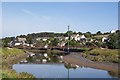
2
The site of Wadebridge railway station
This is the site of Wadebridge railway station, first opened in 1834. The canopied station building (middle distance), which dates from 1899 when the connecting line from Exeter (and ultimately London Waterloo) opened, remains and is now used as the John Betjeman Centre. The old goods shed also survives as an arts centre. The road runs over the site of a second platform and the houses on the right cover the site of the old engine shed.
Image: © Ron Strutt
Taken: 12 Sep 2003
0.09 miles
3
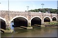
The Old Bridge, Wadebridge
It was built in 1468 by Thomas Lovibond, a vicar of Egloshayle with profits made from the local wool trade. Legend claims that the bridge was built on sacks of the wool to prevent it from sinking into the estuary bed. It was originally 320ft long, 9ft wide and had 17 arches but was later widened to cope with the increasing traffic. For some unknown reason, only 14 of the arches remain.
Image: © Ron Strutt
Taken: 12 Sep 2003
0.09 miles
4
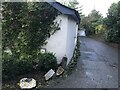
Boundary Stone - Trenant Farm, Wadebridge
Boundary Stone at the north end of Trenant Farm on Trenant Vale
Image: © Tony Houlihan
Taken: 20 Oct 2021
0.15 miles
5
Boundary Stone - Trenant Farm
Boundary stone inscribed R (Rural?) and U (Urban?) at the north end of Trenant Farm on Trenant Vale, Wadebridge
Image: © Tony Houlihan
Taken: 20 Oct 2021
0.15 miles
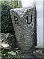
6
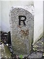
Old Boundary Marker
Municipal Boundary Marker on the southeast side of the unclassified road called Trenant Vale. It was on the boundary of Bodmin Rural District and Wadebridge Urban District between 1894 and 1934, and is now on the boundary of Egloshayle and Wadebridge parishes. Inscribed R (for Bodmin RD) and U (for Wadebridge UD) on adjacent faces.
Milestone Society National ID: CW_WADEGL02pb
Image: © R Hanns
Taken: 29 Sep 2019
0.15 miles
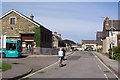
8
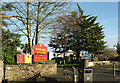
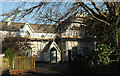
Wadebridge School
The entrance, as the notices indicate, to both the secondary school and the "primary academy".
Image: © Derek Harper
Taken: 30 Jan 2018
0.20 miles
9
House on Gonvena Hill, Wadebridge
Work taking place on an attractive building on the hill above the town.
Image: © Derek Harper
Taken: 30 Jan 2018
0.21 miles
10
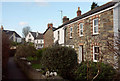
Kimberley Villas, Egloshayle
Footpath 560 5/1 runs past the villas on the right on its 58 metres journey linking a byway to Egloshayle Road.
Image: © Derek Harper
Taken: 4 Feb 2018
0.21 miles