IMAGES TAKEN NEAR TO
Polzeath, WADEBRIDGE, PL27 6SX
Introduction
This page details the photographs taken nearby to PL27 6SX by members of the Geograph project.
The Geograph project started in 2005 with the aim of publishing, organising and preserving representative images for every square kilometre of Great Britain, Ireland and the Isle of Man.

There are currently over 7.5m images from over14,400 individuals and you can help contribute to the project by visiting https://www.geograph.org.uk
Image Map
Images are licensed for reuse under creativecommons.org/licenses/by-sa/2.0
Notes
- Clicking on the map will re-center to the selected point.
- The higher the marker number, the further away the image location is from the centre of the postcode.
Image Listing (43 Images Found)
Images are licensed for reuse under creativecommons.org/licenses/by-sa/2.0
Image
Details
Distance
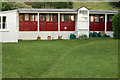
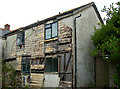
3
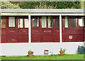
Converted railway carriage, Polzeath (detail)
See [http://www.geograph.org.uk/photo/1469880] for a wider view.
Image: © Andy F
Taken: 22 Aug 2009
0.07 miles
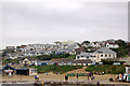
8
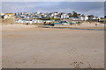
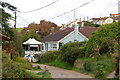
New Polzeath
New Polzeath viewed from Hayle Bay.
Image: © Philip Halling
Taken: 21 Feb 2012
0.11 miles
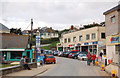
9
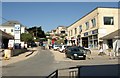
The Parade, Polzeath
Shops in Polzeath catering for those on a surfing holiday. Its closeness to the beach is emphasised by the amount of sand in the road.
Image: © Derek Harper
Taken: 28 Apr 2011
0.12 miles