IMAGES TAKEN NEAR TO
Trebetherick, WADEBRIDGE, PL27 6SQ
Introduction
This page details the photographs taken nearby to PL27 6SQ by members of the Geograph project.
The Geograph project started in 2005 with the aim of publishing, organising and preserving representative images for every square kilometre of Great Britain, Ireland and the Isle of Man.

There are currently over 7.5m images from over14,400 individuals and you can help contribute to the project by visiting https://www.geograph.org.uk
Image Map (Loading...)


Getting Data...Please wait
Leaflet Map data © OpenStreetMap
Images are licensed for reuse under creativecommons.org/licenses/by-sa/2.0
Notes
- Clicking on the map will re-center to the selected point.
- The higher the marker number, the further away the image location is from the centre of the postcode.
Image Listing (9 Images Found)
Images are licensed for reuse under creativecommons.org/licenses/by-sa/2.0
Image
Details
Distance
1
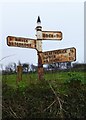
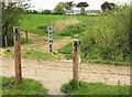
Old Direction Sign - Signpost, Trewint Lane and Trewiston Lane junction, Trewint
Pyramid spear finial - 3 arms; Cornwall CC iron spear by the UC road, in parish of St Minver Highlands (North Cornwall District), Trewint Lane T-junction with Trewiston Lane, in hedge.
Surveyed
Milestone Society National ID: CW_SW9377
Image: © Alan Rosevear
Taken: 20 Mar 2014
0.16 miles
2
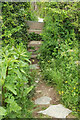
Stile near Trebetherick
A stone stile carrying footpath 547 6/2 from the field shown in Image] into a cul-de-sac off the road between Rock and Trebetherick.
Image: © Derek Harper
Taken: 18 May 2021
0.20 miles
3
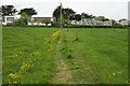
Path towards St Enodoc's church
Footpath 547 6/2 crossing the field in the background of Image] towards houses on cul-de-sacs off the road between Rock and Trebetherick.
Image: © Derek Harper
Taken: 18 May 2021
0.20 miles
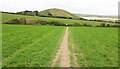
4
Stile on path to St Enodoc's church
A stone stile leads onto footpath 547 22/2, which continues the line of footpath 547 6/2 across the road between Rock and Trebetherick. Brea Hill is beyond the church.
Image: © Derek Harper
Taken: 18 May 2021
0.21 miles
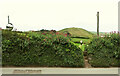
5
Path and track near Trebetherick
Footpath 547 6/2 crosses a track as it approaches houses on the road between Rock and Trebetherick.
Image: © Derek Harper
Taken: 18 May 2021
0.22 miles
6
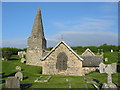
St. Enodoc Church
The spire does seem to be a little twisted. The church is in the middle of a golf course.
Image: © Clive Perrin
Taken: 12 Sep 2005
0.23 miles
7
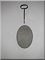
Trebetherick, St Enodoc Church
A plaque for Ernest Betjemann, father of Sir John Betjeman (who is buried in the church graveyard.) Note the spelling on the plaque showing "Betjemann" with two 'n's as the family name was initially spelled before the second one was dropped.
Image: © Neil Kennedy
Taken: 15 Sep 2002
0.23 miles
8
Path to St Enodoc's church
Footpath 547 6/2 seen looking left from Image The spire of the church can be seen towards the left, Brea Hill is in the centre, and the Camel estuary is on the right.
Image: © Derek Harper
Taken: 18 May 2021
0.24 miles
9
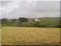
Trenain Farm
the farm road comes in from the left. The farmhouse has been much improved and the land borders St Enedoc Golf course and St Enedoc Church (both to the right)
Image: © William Bartlett
Taken: 26 Aug 2006
0.25 miles