IMAGES TAKEN NEAR TO
St. Minver, WADEBRIDGE, PL27 6RS
Introduction
This page details the photographs taken nearby to PL27 6RS by members of the Geograph project.
The Geograph project started in 2005 with the aim of publishing, organising and preserving representative images for every square kilometre of Great Britain, Ireland and the Isle of Man.

There are currently over 7.5m images from over14,400 individuals and you can help contribute to the project by visiting https://www.geograph.org.uk
Image Map (Loading...)


Getting Data...Please wait
Leaflet Map data © OpenStreetMap
Images are licensed for reuse under creativecommons.org/licenses/by-sa/2.0
Notes
- Clicking on the map will re-center to the selected point.
- The higher the marker number, the further away the image location is from the centre of the postcode.
Image Listing (4 Images Found)
Images are licensed for reuse under creativecommons.org/licenses/by-sa/2.0
Image
Details
Distance
1
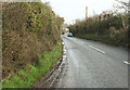
Keiro Lane
Looking in the opposite direction from where Image was taken. Ahead is St Minver Lodge.
Image: © Derek Harper
Taken: 31 Jan 2018
0.10 miles
2
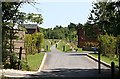
Footpath through a Holiday Estate
This footpath runs through a large holiday village south of St Minver village.
Image: © Tony Atkin
Taken: 15 Jul 2006
0.18 miles
3
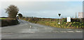
Keiro Lane
From the crossroads where http://www.geograph.org.uk/search.php?i=82756677 were taken, looking across the B3314. The signs are for St Minver Holiday park and the St Enodoc Hotel.
Image: © Derek Harper
Taken: 31 Jan 2018
0.22 miles
4
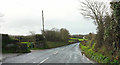
Keiro Lane
Seen near Great Keiro. Image looks the other way.
Image: © Derek Harper
Taken: 31 Jan 2018
0.24 miles