IMAGES TAKEN NEAR TO
St. Minver, WADEBRIDGE, PL27 6RD
Introduction
This page details the photographs taken nearby to PL27 6RD by members of the Geograph project.
The Geograph project started in 2005 with the aim of publishing, organising and preserving representative images for every square kilometre of Great Britain, Ireland and the Isle of Man.

There are currently over 7.5m images from over14,400 individuals and you can help contribute to the project by visiting https://www.geograph.org.uk
Image Map (Loading...)


Getting Data...Please wait
Leaflet Map data © OpenStreetMap
Images are licensed for reuse under creativecommons.org/licenses/by-sa/2.0
Notes
- Clicking on the map will re-center to the selected point.
- The higher the marker number, the further away the image location is from the centre of the postcode.
Image Listing (4 Images Found)
Images are licensed for reuse under creativecommons.org/licenses/by-sa/2.0
Image
Details
Distance
1
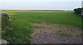
Field near Quin Cross
The hedge on the right surrounds a garden.
Image: © Derek Harper
Taken: 27 Apr 2011
0.08 miles
2
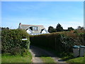
West Winds
The house on the awkward junction
Image: © William Bartlett
Taken: 6 Apr 2007
0.10 miles
3
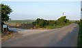
Farm entrance, Lower Trevigo
On the road from Quin Cross to Plain Street.
Image: © Derek Harper
Taken: 27 Apr 2011
0.13 miles
4
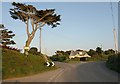
Quin Cross
The principal road veers to the right here, crossing immediately into Image The gaunt cedar is between turns to Port Quin (sharp left) and Plain Street.
Image: © Derek Harper
Taken: 27 Apr 2011
0.17 miles