IMAGES TAKEN NEAR TO
Churchtown, WADEBRIDGE, PL27 6QH
Introduction
This page details the photographs taken nearby to Churchtown, PL27 6QH by members of the Geograph project.
The Geograph project started in 2005 with the aim of publishing, organising and preserving representative images for every square kilometre of Great Britain, Ireland and the Isle of Man.

There are currently over 7.5m images from over14,400 individuals and you can help contribute to the project by visiting https://www.geograph.org.uk
Image Map (Loading...)


Getting Data...Please wait
Leaflet Map data © OpenStreetMap
Images are licensed for reuse under creativecommons.org/licenses/by-sa/2.0
Notes
- Clicking on the map will re-center to the selected point.
- The higher the marker number, the further away the image location is from the centre of the postcode.
Image Listing (33 Images Found)
Images are licensed for reuse under creativecommons.org/licenses/by-sa/2.0
Image
Details
Distance
1
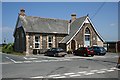
Perceval Institute, St Minver
Whatever this building was built for originally it is now used as the St Minver Village Hall.
Image: © Tony Atkin
Taken: 15 Jul 2006
0.03 miles
2
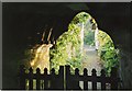
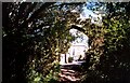
St Miniver church gateway
Dappled sunlight through the parish church gateway.
Image: © colin adamson
Taken: 6 Nov 2007
0.03 miles
3
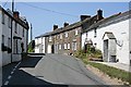
St Minver
In as much as the village of St Minver can be said to have a main road, this is it!
Image: © Tony Atkin
Taken: 15 Jul 2006
0.04 miles
4
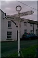
Direction Sign - Signpost at St Minver
Annulus finial - 4 arms; by the UC road, in parish of St Minver Highlands (North Cornwall District), Crossroads, St Minver, opposite Fourways Inn.
Surveyed
Milestone Society National ID: CW_SW9677
Image: © Milestone Society
Taken: Unknown
0.04 miles
5
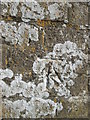
Ordnance Survey Cut Mark
This OS cut mark can be found on the NW face of the Percival Institute Building. It marks a point 72.433m above mean sea level. http://www.geograph.org.uk/photo/4450649
Image: © Adrian Dust
Taken: 20 Apr 2015
0.04 miles
7
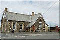
St Minver- Perceval Institute,
Village Hall.
Image: © Ian Rob
Taken: 22 Jun 2015
0.05 miles
8
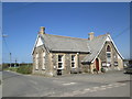
Percival Institute
There is an Ordnance Survey cut mark on the NE face. http://www.geograph.org.uk/photo/4450645
Image: © Adrian Dust
Taken: 20 Apr 2015
0.05 miles
9
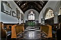
St. Minver, St. Menefreda's Church: The chancel
Image: © Michael Garlick
Taken: 27 Jun 2019
0.05 miles
10
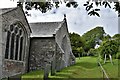
St. Minver, St. Menefreda's Church: Along the eastern aspect
Image: © Michael Garlick
Taken: 27 Jun 2019
0.05 miles