IMAGES TAKEN NEAR TO
Pityme Industrial Estate, WADEBRIDGE, PL27 6NS
Introduction
This page details the photographs taken nearby to Pityme Industrial Estate, PL27 6NS by members of the Geograph project.
The Geograph project started in 2005 with the aim of publishing, organising and preserving representative images for every square kilometre of Great Britain, Ireland and the Isle of Man.

There are currently over 7.5m images from over14,400 individuals and you can help contribute to the project by visiting https://www.geograph.org.uk
Image Map
Images are licensed for reuse under creativecommons.org/licenses/by-sa/2.0
Notes
- Clicking on the map will re-center to the selected point.
- The higher the marker number, the further away the image location is from the centre of the postcode.
Image Listing (5 Images Found)
Images are licensed for reuse under creativecommons.org/licenses/by-sa/2.0
Image
Details
Distance
1
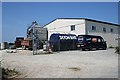
Sharps Brewery
Walking along the road I smelt something sweet. At first I thought it was the farmyard silage smell but that smell is rather vile and sickly, this was much more pleasant. It was a mystery to me until I came upon this sight. A brewery!
Image: © Tony Atkin
Taken: 15 Jul 2006
0.10 miles
2
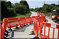
Roadworks at Pityme
More red plastic than a children's toy box. The village is called Pityme and the roadworks are a local problem. Behind the photographer the road is totally closed causing long diversions and delays. This work was due to end before the peak summer holiday rush but according to local residents it is running behind schedule. It seems like the village is aptly named.
Image: © Tony Atkin
Taken: 15 Jul 2006
0.17 miles
3
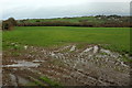
Farmland near Pityme
The field is crossed by footpath 546/11/1. On the right is the spire of the church at St Minver.
Image: © Derek Harper
Taken: 31 Jan 2018
0.22 miles
4
Towards West Pearls
Looking right from where Image was taken. West Pearls is the farm in the centre, in Image Footpath 546/11/1 crosses this corner of the field
Image: © Derek Harper
Taken: 31 Jan 2018
0.23 miles
5
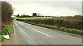
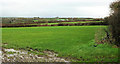
Road east from Pityme
From the gateway where Image] was taken. The road here is used by the parish boundary between St Minver Highlands (left) and St Minver Lowlands. The farm ahead is Bennett's Keiro.
Image: © Derek Harper
Taken: 31 Jan 2018
0.23 miles