IMAGES TAKEN NEAR TO
Lower Greenbanks, WADEBRIDGE, PL27 6NA
Introduction
This page details the photographs taken nearby to Lower Greenbanks, PL27 6NA by members of the Geograph project.
The Geograph project started in 2005 with the aim of publishing, organising and preserving representative images for every square kilometre of Great Britain, Ireland and the Isle of Man.

There are currently over 7.5m images from over14,400 individuals and you can help contribute to the project by visiting https://www.geograph.org.uk
Image Map
Images are licensed for reuse under creativecommons.org/licenses/by-sa/2.0
Notes
- Clicking on the map will re-center to the selected point.
- The higher the marker number, the further away the image location is from the centre of the postcode.
Image Listing (12 Images Found)
Images are licensed for reuse under creativecommons.org/licenses/by-sa/2.0
Image
Details
Distance
1
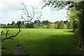
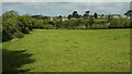
Field near Rock
From the footpath crossroads partly shown in Image], looking towards houses on Sandyhills.
Image: © Derek Harper
Taken: 18 May 2021
0.13 miles

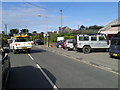
4
Rock Shops
The post office, and a footpath, is on the far right of this block of shops.
Image: © William Bartlett
Taken: 8 Apr 2007
0.20 miles
5
Field near Rock
A view from a track, shown in Image], linking Porthilly and Trevesa Farm.
Image: © Derek Harper
Taken: 18 May 2021
0.21 miles
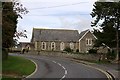
6
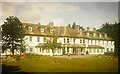
Dormy House Hotel, Rock Road, Rock in 1965
My parents and I stayed at the hotel from 3-14 September 1965 having travelled 277 miles from our house in Hertfordshire see http://www.geograph.org.uk/photo/1756312 The building is now known as Lowenna Manor and is described as comprising of 10 luxury houses in the form of a terrace. The monkey puzzle tree still stands although it has grown enormously.
Image: © John Baker
Taken: 4 Sep 1965
0.22 miles
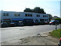
7
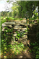
Stone stile near Treverrow
On the far side of the footpath crossroads in Image], with a stone stile taking footpath 547 13/8 towards Rock along the edge of the field shown in Image
Image: © Derek Harper
Taken: 18 May 2021
0.22 miles
8
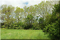
Corner of field by Treverrow
Approaching a footpath crossroads where footpath 547 13, which I am following, crosses a track carrying footpath 547 12. This looks in the opposite direction from Image
Image: © Derek Harper
Taken: 18 May 2021
0.23 miles
9
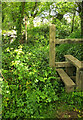
Stiles near Treverrow
The second, stone, stile is partly obscured behind a tree. It leads footpath 547 13/9 onto a track from Porthilly to Trevesa Farm. Houses at Rock can be glimpsed in the distance.
Image: © Derek Harper
Taken: 18 May 2021
0.23 miles