IMAGES TAKEN NEAR TO
Rock, WADEBRIDGE, PL27 6JX
Introduction
This page details the photographs taken nearby to PL27 6JX by members of the Geograph project.
The Geograph project started in 2005 with the aim of publishing, organising and preserving representative images for every square kilometre of Great Britain, Ireland and the Isle of Man.

There are currently over 7.5m images from over14,400 individuals and you can help contribute to the project by visiting https://www.geograph.org.uk
Image Map (Loading...)


Getting Data...Please wait
Leaflet Map data © OpenStreetMap
Images are licensed for reuse under creativecommons.org/licenses/by-sa/2.0
Notes
- Clicking on the map will re-center to the selected point.
- The higher the marker number, the further away the image location is from the centre of the postcode.
Image Listing (42 Images Found)
Images are licensed for reuse under creativecommons.org/licenses/by-sa/2.0
Image
Details
Distance
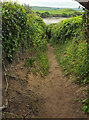
1
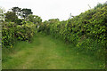
Footpath, Rock
Footpath 547/14/3 follows a grassy track between hedges towards Rock Road.
Image: © Derek Harper
Taken: 17 May 2021
0.08 miles
2
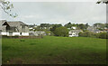
Field and houses, Porthilly
From the gate shown in Image
Image: © Derek Harper
Taken: 17 May 2021
0.08 miles
3
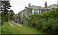
Lynam Court
Footpath 547/14/3 runs past this "18th-century house ... used to provide refuge to Thai royals during the second world war" https://www.latitude50.co.uk/explore-our-properties/north-cornwall/rock/lynam .
Image: © Derek Harper
Taken: 17 May 2021
0.09 miles
4
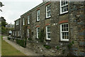
Lynam Court
A closer look at Image], again from footpath 547/14/3.
Image: © Derek Harper
Taken: 17 May 2021
0.09 miles
5
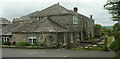
Lynam Court
Looking in the opposite direction to Image] and Image]: this "18th-century house ... used to provide refuge to Thai royals during the second world war" https://www.latitude50.co.uk/explore-our-properties/north-cornwall/rock/lynam . It is now available as holiday accommodation.
Image: © Derek Harper
Taken: 17 May 2021
0.10 miles
6
Footpath to Porthilly Cove
Footpath 547/14/3 runs down between hedgebanks from Rock Road. It's a necessary alternative to the beach when the tide is high.
Image: © Derek Harper
Taken: 17 May 2021
0.10 miles
7
Path to Porthilly Cove
Footpath 547/14/3 seen looking right from Image
Image: © Derek Harper
Taken: 17 May 2021
0.11 miles
8
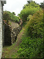
Cornish hedge, Rock
By a small path leading off footpath 547/14/3.
Image: © Derek Harper
Taken: 17 May 2021
0.11 miles
9
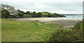
Seat, Porthilly Cove
On the left is the grade II* listed Church of St Michael, "Chapelry ... Circa C12 church with main structure of nave, chancel and south transept surviving" https://historicengland.org.uk/listing/the-list/list-entry/1124714 ), a very thorough description). See also Image Away across the Camel estuary is Padstow.
Image: © Derek Harper
Taken: 17 May 2021
0.11 miles
10
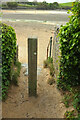
Path reaching Porthilly Cove
Footpath 547/14/3, shown in Image, reaches its conclusion.
Image: © Derek Harper
Taken: 17 May 2021
0.11 miles