IMAGES TAKEN NEAR TO
Broad Park Close, WADEBRIDGE, PL27 6JP
Introduction
This page details the photographs taken nearby to Broad Park Close, PL27 6JP by members of the Geograph project.
The Geograph project started in 2005 with the aim of publishing, organising and preserving representative images for every square kilometre of Great Britain, Ireland and the Isle of Man.

There are currently over 7.5m images from over14,400 individuals and you can help contribute to the project by visiting https://www.geograph.org.uk
Image Map (Loading...)


Getting Data...Please wait
Leaflet Map data © OpenStreetMap
Images are licensed for reuse under creativecommons.org/licenses/by-sa/2.0
Notes
- Clicking on the map will re-center to the selected point.
- The higher the marker number, the further away the image location is from the centre of the postcode.
Image Listing (2 Images Found)
Images are licensed for reuse under creativecommons.org/licenses/by-sa/2.0
Image
Details
Distance
1

Roadworks at Pityme
More red plastic than a children's toy box. The village is called Pityme and the roadworks are a local problem. Behind the photographer the road is totally closed causing long diversions and delays. This work was due to end before the peak summer holiday rush but according to local residents it is running behind schedule. It seems like the village is aptly named.
Image: © Tony Atkin
Taken: 15 Jul 2006
0.17 miles
2
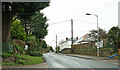
Rock Road, Pityme
The road out of Rock, heading east-north-east.
Image: © Derek Harper
Taken: 31 Jan 2018
0.17 miles