IMAGES TAKEN NEAR TO
Egloshayle, WADEBRIDGE, PL27 6JH
Introduction
This page details the photographs taken nearby to PL27 6JH by members of the Geograph project.
The Geograph project started in 2005 with the aim of publishing, organising and preserving representative images for every square kilometre of Great Britain, Ireland and the Isle of Man.

There are currently over 7.5m images from over14,400 individuals and you can help contribute to the project by visiting https://www.geograph.org.uk
Image Map (4 Images)


Leaflet Map data © OpenStreetMap
Images are licensed for reuse under creativecommons.org/licenses/by-sa/2.0
Notes
- Clicking on the map will re-center to the selected point.
- The higher the marker number, the further away the image location is from the centre of the postcode.
Image Listing (4 Images Found)
Images are licensed for reuse under creativecommons.org/licenses/by-sa/2.0
Image
Details
Distance
1
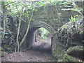
The Withered Arm - Bridge 140 - Treworder Cattle Creep
This view of Bridge 140 on the old North Cornwall Railway, (ex LSWR, and Southern railway), is taken from the track to Treworder farm, for which the bridge was built.
Image: © Dave Oram
Taken: 14 May 2011
0.16 miles
2
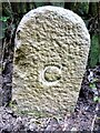
Old Boundary Marker
County Bridge Marker on the southeast side of the road northeast of Kestle Bridge and west of Sladesbridge. Egloshayle parish. Inscribed C. The stone marks the extent of roadway adjoining the bridge that the County was obliged to maintain.
Milestone Society National ID: CW_EGLO02br
Image: © R Hanns
Taken: 13 Oct 2019
0.21 miles
3
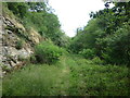
The Withered Arm - The Allen Valley
This view is taken just above Sladesbridge in the Allen Valley, where the line descended the valley on the north side, terraced into the steep valley side. The gradient along this stretch was falling at 1:75 towards the Camel Valley.
Image: © Dave Oram
Taken: 14 May 2011
0.22 miles
4
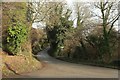
Road by Kestle Quarry
The road, to St Mabyn, has just left the A389 and crossed a tributary of the Camel. Image] shows the view the other way.
Image: © Derek Harper
Taken: 22 Jan 2017
0.24 miles