IMAGES TAKEN NEAR TO
Sladesbridge, WADEBRIDGE, PL27 6JB
Introduction
This page details the photographs taken nearby to PL27 6JB by members of the Geograph project.
The Geograph project started in 2005 with the aim of publishing, organising and preserving representative images for every square kilometre of Great Britain, Ireland and the Isle of Man.

There are currently over 7.5m images from over14,400 individuals and you can help contribute to the project by visiting https://www.geograph.org.uk
Image Map (Loading...)


Getting Data...Please wait
Leaflet Map data © OpenStreetMap
Images are licensed for reuse under creativecommons.org/licenses/by-sa/2.0
Notes
- Clicking on the map will re-center to the selected point.
- The higher the marker number, the further away the image location is from the centre of the postcode.
Image Listing (40 Images Found)
Images are licensed for reuse under creativecommons.org/licenses/by-sa/2.0
Image
Details
Distance
1
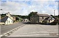
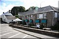
Sladesbridge on the A389 Wadebridge to Bodmin Road
Looking towards Bodmin at Sladesbridge
Image: © roger geach
Taken: 23 Sep 2010
0.01 miles
2
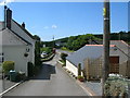
Sladesbridge : The A389
A road heading through the village.
Image: © Lewis Clarke
Taken: 10 Jul 2017
0.02 miles
4
Sladesbridge : The A389
A road heading through Sladesbridge.
Image: © Lewis Clarke
Taken: 10 Jul 2017
0.04 miles
5
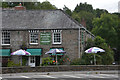
Sladesbridge : Slades House Country Inn
A pub on the A389.
Image: © Lewis Clarke
Taken: 10 Jul 2017
0.05 miles
6
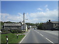
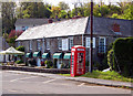
Sladesbridge
At the telephone box is a junction where the steep lane from Pendavey joins the main Wadebridge to Bodmin road. Trelawney garden centre is just visible on the other side of the road over the River Allen (runs under the road here).
Image: © William Bartlett
Taken: 29 May 2007
0.05 miles
7
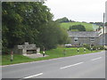
Commemorative seat beside the A389 at Sladesbridge
According to the plaque on the back of this elaborate seat it was erected by Egloshayle Parish Council to commemorate the Silver Jubilee of Her Majesty Queen Elizabeth II 1952-1977.
Image: © Rod Allday
Taken: 24 Jul 2011
0.06 miles
8
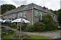
Sladesbridge : Slades House Country Inn
Farmhouse. Later public house with attached malt house and now used as public house. Circa late C17, remodelled in mid C18, extended in early and mid C19 and rear wing rebuilt in late C20. https://historicengland.org.uk/listing/the-list/list-entry/1143057
Image: © Lewis Clarke
Taken: 10 Jul 2017
0.06 miles
9
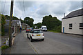
Slades House Inn
On the road from Bodmin to Wadebridge, this Inn is situated slightly back from the main road.
Image: © roger geach
Taken: 23 Sep 2010
0.06 miles
10
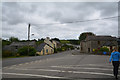
The pub at Sladesbridge
Slades House Country Inn stands beside the A389 Wadebridge to Bodmin road.
Image: © Andy F
Taken: 2 May 2009
0.06 miles