IMAGES TAKEN NEAR TO
Green Hill, WADEBRIDGE, PL27 6GD
Introduction
This page details the photographs taken nearby to Green Hill, PL27 6GD by members of the Geograph project.
The Geograph project started in 2005 with the aim of publishing, organising and preserving representative images for every square kilometre of Great Britain, Ireland and the Isle of Man.

There are currently over 7.5m images from over14,400 individuals and you can help contribute to the project by visiting https://www.geograph.org.uk
Image Map
Images are licensed for reuse under creativecommons.org/licenses/by-sa/2.0
Notes
- Clicking on the map will re-center to the selected point.
- The higher the marker number, the further away the image location is from the centre of the postcode.
Image Listing (18 Images Found)
Images are licensed for reuse under creativecommons.org/licenses/by-sa/2.0
Image
Details
Distance
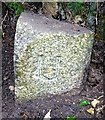
1
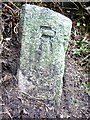
Old Boundary Marker
Municipal Boundary Marker on the southeast side of the unclassified road Green Hill. It was on the boundary of Bodmin Rural District and Wadebridge Urban District between 1894 and 1934, and is now on the boundary of Egloshayle and Wadebridge parishes. Inscribed R (for Bodmin RD) and U (for Wadebridge UD) on adjacent faces.
Milestone Society National ID: CW_WADEGL04pb
Image: © R Hanns
Taken: 29 Sep 2019
0.06 miles
2
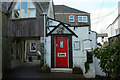
The She, Wadebridge
The D's gone from this cafe name in the heart of town.
Image: © Derek Harper
Taken: 3 Feb 2018
0.11 miles
3
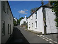
Egloshayle
Looking up the street near the church (behind photographer). The lane on the right leads to the Earl of St Vincent pub
Image: © William Bartlett
Taken: 29 May 2007
0.13 miles
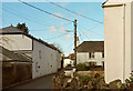
4

Tower Hill, Egloshayle
Cottages up the hill from where Image was taken. Ahead is a new build.
Image: © Derek Harper
Taken: 24 Jan 2017
0.14 miles
5
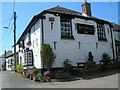
The Earl of St Vincent
Built as a boarding house for the masons who constructed the church down the lane in the 12th century and now named after a former Admiral who sailed with Nelson.
Image: © William Bartlett
Taken: 29 May 2007
0.18 miles
6
Higher Lane, Egloshayle
Looking past the Earl of St Vincent.
Image: © Derek Harper
Taken: 4 Feb 2018
0.19 miles
7
Old Boundary Marker
Municipal Boundary Marker on the southeast side of the unclassified road called Treworder Lane. It was on the boundary of Bodmin Rural District and Wadebridge Urban District between 1894 and 1934, and is now on the boundary of Egloshayle and Wadebridge parishes. Inscribed R (for Bodmin RD) and U (for Wadebridge UD) on adjacent faces.
Milestone Society National ID: CW_WADEGL05pb
Image: © R Hanns
Taken: 29 Sep 2019
0.19 miles
8

Hopper, Egloshayle
A distinctive piece of advertising for a local plumber on the hopper of a cottage downpipe near the church in Egloshayle.
Image: © Derek Harper
Taken: 24 Jan 2017
0.20 miles
9

Houses on Egloshayle Road
The three-bay house on the right is listed https://www.historicengland.org.uk/listing/the-list/list-entry/1162523 .
Image: © Derek Harper
Taken: 24 Jan 2017
0.20 miles
10

Houses on Egloshayle Road
From where Image] was taken, looking left. In the foreground a mini-roundabout at the junction with a link road to West Park Estate.
Image: © Derek Harper
Taken: 24 Jan 2017
0.22 miles