IMAGES TAKEN NEAR TO
WADEBRIDGE, PL27 6EX
Introduction
This page details the photographs taken nearby to PL27 6EX by members of the Geograph project.
The Geograph project started in 2005 with the aim of publishing, organising and preserving representative images for every square kilometre of Great Britain, Ireland and the Isle of Man.

There are currently over 7.5m images from over14,400 individuals and you can help contribute to the project by visiting https://www.geograph.org.uk
Image Map (16 Images)


Getting Data...Please wait
Leaflet Map data © OpenStreetMap
Images are licensed for reuse under creativecommons.org/licenses/by-sa/2.0
Notes
- Clicking on the map will re-center to the selected point.
- The higher the marker number, the further away the image location is from the centre of the postcode.
Image Listing (16 Images Found)
Images are licensed for reuse under creativecommons.org/licenses/by-sa/2.0
Image
Details
Distance
2
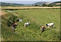
Cattle in the River
I don't think it was the farmer's intention that the cattle should be here. Beyond these fields is the Camel Estuary. These fields would have been a muddy creek until an embankment was built to separate this area from the Estuary.
Image: © Tony Atkin
Taken: 15 Jul 2006
0.15 miles
3
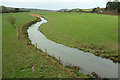
River Amble
Looking downstream from Trewornan Bridge, and exceedingly similar to Image In the distance is the Camel estuary.
Image: © Derek Harper
Taken: 30 Jan 2018
0.15 miles
4
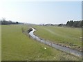
Amble flood plain from the B3314
From a little southeast of Trewornan Bridge, looking downstream along the stretch of the river shown in Image]; the estuary is again visible.
Image: © Derek Harper
Taken: 30 Jan 2018
0.15 miles
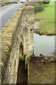
6
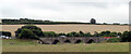
Trewornan Bridge
A view along the downstream side of the listed bridge https://www.historicengland.org.uk/listing/the-list/list-entry/1143055 (also an Ancient Monument) taking the B3314 over the River Amble. "Despite some repairs, the pretty multi-span bridge called Trewornan Bridge with its medieval design survives well and was regarded by {Charles} Henderson as the only post-Reformation bridge in Cornwall worth visiting" https://www.historicengland.org.uk/listing/the-list/list-entry/1004484 .
Image: © Derek Harper
Taken: 30 Jan 2018
0.16 miles
8
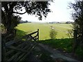
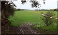
Track to water-meadows beside the River Amble
The entrance can be seen in front of the traffic light on the left hand side of the road Image
Image: © John Baker
Taken: 28 Mar 2013
0.16 miles
9
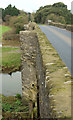
Trewornan Bridge
A view along the upstream side of the listed bridge https://www.historicengland.org.uk/listing/the-list/list-entry/1143055 (also an Ancient Monument) taking the B3314 over the River Amble. Image] shows the downstream side. "The stone rubble parapets are carried out over the cutwaters to form refuges".
Image: © Derek Harper
Taken: 30 Jan 2018
0.16 miles
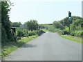
10

Lay-by near Trewornan Bridge
Traffic lights have been installed due to the narrowness of the B3314 over the bridge.
Image: © John Baker
Taken: 28 Mar 2013
0.17 miles